
Identifying spatially differentiated pathways for rural transformation in Pakistan1
Abstract
This paper proposes a conceptual and empirical framework to develop rural transformation strategies tailored to the agroecological potential and market access of rural areas in Pakistan. Such a framework allows to move away from stereotypical countrywide policies as in use in Pakistan and many other countries. Using publicly available geospatial measures of vegetation greenness and an urban gravity model to proxy the agricultural market demand, we classify Pakistan’s rural districts into categories with similar comparative advantages and describe dominant livelihood activities. The framework recommends market-based approaches to support commercial agriculture or non-agriculture business development in well-connected areas and where households have accumulated human and physical capital. In areas with less developed agricultural potential or market access, households will benefit from area-based and community-driven development, skill development, and labor programs. Since data collection is often challenging in rural areas, statistical agencies can use such an empirical framework to advise policymakers on prioritizing public investments and tailoring rural transformation pathways. In addition, statistical agencies can also extend the framework at different levels of resolution, from national to local level, and complement it with primary data sources to validate the usefulness of the approach.
1.Introduction
Rural transformation helps to make the economic activities of rural households more productive, efficient, and commercial as rural areas become increasingly integrated with markets. In the transformation process, rural areas will increase agricultural productivity but reduce reliance on the agricultural sector; increase commercialization and marketing of output; increase reliance on trade for goods, services, and ideas; and diversify production patterns and livelihoods towards off-farm employment and entrepreneurial opportunities [1]. It brings about societal changes as it often implies a move from dispersed villages to towns, small, and medium cities; and better access to services and infrastructure [2].
Historically, the agricultural sector has been the main driver of Pakistan’s economic growth, with the Green Revolution increasing productivity through high-yielding varieties, fertilizers, pesticides, and tube well irrigation. These policies rolled out as a blanket over large parts of the country were highly successful in the 20th century in improving Pakistan’s food security and contributing to income growth. Nevertheless, the continued focus on rice and wheat production using distortionary instruments to achieve self-sufficiency is now outdated because of emerging market opportunities in food systems and challenges in rural areas related to climate change, natural resource degradation, extreme weather events, and youth outmigration. It has also diverted resources from investments to improve competitiveness, build resilience, or tap into emerging opportunities, including the rural nonfarm and off-farm economy, social services, and skill development.
Addressing the location-specific needs in rural areas requires a fundamental shift in Pakistan’s rural policymaking. Traditionally, rural policymaking in Pakistan has been centrally decided. But, since the 18th Amendment in 2010 devolved the responsibility and resources for rural governance and development to the provinces, Pakistan lacks a comprehensive rural development policy at the national level. Policies affecting rural Pakistan are generally defined along sectoral lines, such as agriculture, irrigation, or education programs. Relatively weak local governments, insufficient engagement with grassroots community networks, and a historic influence of large landholders on policymaking have made local rural development ad hoc, fragmented, uncoordinated, and unresponsive to specific needs.
New approaches for rural development within and outside Pakistan must consider the entirety of the rural opportunity space, which comprises the set of opportunities and constraints for rural livelihood strategies determined by the national, local, and household contexts [3]. At the local level, agroecological potential, market access, and local institutions vary and interact to influence households’ production and marketing patterns. Indeed, a vast literature has looked at how the local dimensions of market access and agroecological potential predict comparative advantages, choices, and outcomes in agricultural production, non-farm activities, and other livelihood activities [4, 5, 6, 7, 8, 9, 10, 11, 12].
While the rural opportunity space concept provides a useful and comprehensive understanding of the evolving and multisectoral challenges in rural areas, an empirical framework is needed to translate the concept into specific local policy recommendations. It must also account for the complexity of rural challenges in developing countries where the availability, quality, and cost of granular data can be compromised. Several seminal papers have developed an empirical framework using geospatial information available at the time to proxy the local rural conditions and identify area-based agricultural or rural development strategies in Ethiopia and Uganda [13, 14, 15]. Over time, however, new sources of public geospatial data and more complex methodologies to proxy market access have become available. In addition, such an empirical model has not been implemented in Pakistan.
The paper addresses this gap by building upon the earlier seminal work and using more recent and advanced geospatial proxies to develop an empirical classification of Pakistan’s rural space. These geospatial proxies have been calculated using global open access data, such as the Normalized Difference Vegetation Index (NDVI) surface friction layers representing the cost of movement, and night lights emission data, which has the additional benefit of making the analysis replicable and repeatable with relatively low cost of data collection within and outside Pakistan. In addition, the paper links the geography-based classification with existing primary data sources on the labor market participation, livelihood strategies, and access to services outcomes of households within the districts to help policymakers develop targeted policies and strategies.
Building upon the existing literature, the paper makes three contributions. First, the paper uses more recent but well-established geospatial data sources validated for their methodology and reliability [16] to translate the conceptual approach into an empirical framework. Statistical agencies can use, replicate, and extend the latter framework within and outside Pakistan to classify rural districts based on publicly available geospatial data. Second, it illustrates how statistical agencies and researchers can link geospatial classification with existing primary data sources to develop a deep understanding of how local conditions in rural areas result in regional differences in human behavior outcomes, occupational choices, and socioeconomic indicators of well-being. Lastly, by differentiating the rural space, the paper’s framework can help policymakers move on from traditional blanket approaches (such as Pakistan’s wheat-based policies still grounded in Green Revolution thinking). As the dominant livelihood activity in each type of rural area is likely to be different, so should be the policy actions, interventions, and investment responses to develop these areas further.
Table 1
Categorizing rural space according to their market access and agroecological potential
| Category | Local conditions | Comparative advantage for agriculture | Role of for non-farm sector |
|---|---|---|---|
| I | Low MA, low AEP | Subsistence-oriented farming and extensive pastoral systems to ensure household and local food security | Both low agroecology and market access necessitate employment in non-traded services within the local community |
| II | Medium MA, medium AEP | Traditional, low-input low-output, and semi-subsistence oriented farming systems are integrated with grazing-based small-scale livestock farming. Crop production is for household consumption and livestock assets as a buffer to income shocks | Areas rich in natural resources and ecosystem services can specialize producing niche products (e.g., tourism). Medium market access allows mobility of labor to increase its productivity |
| III | Good MA, medium AEP | Access to markets allows for income generation from large scale production of staples and raw livestock products with little value added | Development of off-farm agribusiness services sector and non-farm activities outside agriculture in commerce, manufacturing, and services. |
| IV | Medium MA, good AEP | Good agroecology allows for high-value agricultural commodities such as cash crops, industrial crops, and fruits and vegetables that need to be processed | Limitations outside agriculture because of the remoteness |
| V | Good MA, good AEP | Both good agroecology and market access allow for specialization in high-value production of fresh fruit and vegetables, spices, and dairy – which require quality standards and a value chain | Good market access and strong linkages between farm and non-farm sectors allow diversified livelihood strategies within agricultural value chains and outside agriculture in small scale manufacturing |
Note: ‘MA’ refers to market access, ‘AEP’ to agroecological potential.
2.Categorizing Pakistan’s rural space
The market access and agroecological potential of rural areas determine the livelihood strategies that households can pursue to earn income and, consequently, the opportunities for agricultural or non-agricultural development. By assessing the relative position (Low, Medium, or High) of rural areas on the market access and agroecological potential dimensions, Table 1 conceptualizes five categories of rural areas in Pakistan, as hypothesized by the literature [4, 5, 6, 7, 8, 9], each with a different mix of livelihood strategies and role of the agriculture and other sectors in driving the rural transformation process.
The first local dimension, market access, is how rural households are integrated into input and output markets (within or outside rural areas). A narrow interpretation of market access is the households’ physical access to markets for input purchase, service rental, output sales, acquiring information, or obtaining financial products [9]. This spatial connectivity is determined by the household’s physical location and the availability and quality of rural infrastructure. More broadly, market access refers to the extent to which households can avail themselves of the opportunities provided by growing urban demand, which is linked to income growth, for more diversified diets or other rural services (e.g., eco-tourism) [8]. Access to urban markets incentivizes households to commercialize their productive activities by participating in high-paying urban markets. More broadly, improved connectivity to urban areas facilitates economic migration, reduces business transaction costs, and generates spillover effects from urban to rural areas in the periphery of cities [12, 17]. As average rural incomes increase, local demand for goods and services also increases, and the local rural economy becomes increasingly diversified and integrated with other markets, accelerating rural transformation.
The second local dimension, agroecological potential, refers to the potential of the land cultivated by households to generate returns to investments made into the land [5, 8]. Land and labor are the main assets of households in rural areas [4]. The inherent quality of the land – conditioned by soil quality and water retention capacity, geology and slope, and climate patterns – together with complementary services – such as access to irrigation – determines the overall potential of the land for different land uses, including agricultural production. Moreover, land quality determines households’ expected returns from investments in the land.
The paper uses geospatial data on market access and agroecological potential and a statistical model to assign rural districts to the conceptual categories and understand their socio-economic characteristics. The analysis clustered 120 districts where most of the population is considered rural. Districts are Pakistan’s third tier of local government after the federal and provincial governments. The paper developed a replication framework that explains the data sources, methodology, and analysis in detail.
The analysis uses an indicator of the greenness of vegetation of the cropland to proxy the realized agroecological potential of a rural district. The NDVI measures the vegetation greenness of the earth’s surface and captures the realized agroecological potential as it reflects the actual vegetation cover, not the inherent potential of the (crop)land. Geospatial literature considers NDVI a robust proxy of land quality [3, 8, 16, 19]. The analysis collected the raw monthly NDVI data from the NASA Harvest Glam database, aggregated to annual data, applied a crop mask to identify cropland, and then aggregated it at the district level (applying appropriate weights to address the modifiable areal unit problem). The analysis then measured the NDVI per crop area to account for the district size.
The analysis employs the urban pull or ‘gravity’ of agricultural markets as a measure of market access for rural districts. The location of 302 agricultural markets relevant for agricultural sales were obtained in each province from government sources and verified through literature review and online research. The analysis uses an adapted urban gravity model introduced by Binswanger and Savastano [8]. The model uses nighttime light intensity (from the Visible and Infrared Imaging Suite sensor), which is assumed to correlate with the size of urban consumers’ demand for agricultural products at agricultural markets, as a geospatial measure of economic activity. The analysis measures the ease of rural districts’ physical access to this demand by calculating the time it takes to travel from a rural market to any agricultural market in Pakistan. The travel time is calculated using the global friction surface of Weiss et al. [20], which considers road quality, topography, and travel obstructions. To account for the fact that remoteness reduces the pull of agricultural markets on producers, the travel time is converted into a negative exponential travel decay function. Finally, the size of urban demand and the ease of accessing the demand are combined to create the final urban gravity indicator.
The analysis assigns rural districts to categories that maximize the similarity within but difference across categories based on each district’s ranking on the proxies for market access and agroecological potential. First, each rural district was ranked based on its geospatial proxies for agroecological potential and market access. Second, a data-driven clustering technique assigned rural districts to a pre-defined number (five) of groups similar in their market access and agroecological potential. The partition clustering technique measures the similarity between rural districts based on the distance of each district (using the rankings) from the center of a group and maximizes the similarity of the rural districts in each group. Partition clustering was preferred over agglomerative hierarchical clustering because it yielded the highest statistical accuracy (assessed by the statistical tests offered by the ‘discriminant analysis’ and ‘cluster-analysis stopping rules’ explained in the annex) and was validated by experts.
Classifying the rural space of Pakistan on market access and agroecological potential has its limitations in capturing the historical, institutional, and political factors of rural transformation. Other local conditions – such as political economy, wealth distribution, and vulnerability to climate change – affect production patterns [18]. Pakistan has a complex history of land ownership, distribution, tenure security, and enforcement, where (large) landowners do not necessarily derive their primary income from agricultural production. Households’ endowment of human and social capital and the quality of local institutions also influence the ability of rural communities to capitalize on local opportunities emerging from their market access and agroecological potential. For instance, educated households are more likely to engage in commercial, instead of subsistence farming and invest in productivity-enhancing farming practices to produce a surplus.
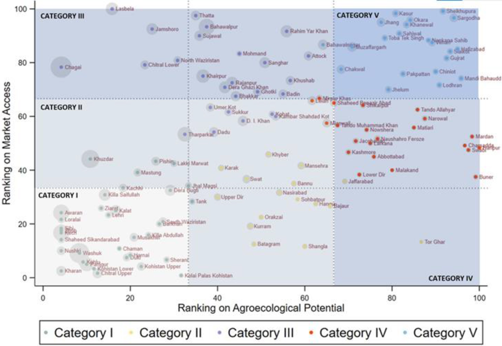
Figure 1.
Categories of rural districts created by the clustering technique and their location.
3.Socio-economic differences between rural districts
Figure 1 presents the five categories of rural districts. Category I contains 35 rural districts mostly situated in the plateaus and mountains of Balochistan and parts of south and North Khyber Pakhtunkhwa. Although it has a low population density, it still represents 9% of the rural population. Category II comprises 16 rural districts located primarily in Khyber Pakhtunkhwa and Balochistan, representing 11% of the rural population. Category III covers 26 rural districts, representing 31% of the rural population, with high market access but varying levels of agroecological potential. They are located near major cities in Sindh, Punjab, and Balochistan but not as close as districts in Category V. Category IV includes 22 rural districts, representing 17% of the rural population, with intermediate market access and high agroecological potential due to their loamy and sandy soils. Category V has 21 rural districts representing 32% of the rural population. These densely populated rural districts are mainly in Punjab’s northern irrigated plains, with excellent market access and agroecological potential. The Indus basin has a dense network of irrigation infrastructure and road networks linking them to Lahore, Faisalabad, Rawalpindi, and Gujranwala, the regional metropoles.
The analysis then used the Pakistan Living Standard Measurement (PSLM) survey of 2019–20, covering 110 districts out of the 120 classified districts, to understand the participation of rural individuals in the labor force and rural subsectors. In particular, the analysis uses the PSLM information on the main occupation of individuals of working age (i.e., above 15 years and below 65 years) and economically active and to measure household’s access to basic services as well as higher-level development outcomes such as poverty and literacy rates.
Table 2
Summary statistics per categories of rural districts
| Category | I | II | III | IV | V |
| Indicators used in clustering technique | |||||
| Normalized Difference Vegetation Index (value per km2) | 0.2 | 2.2 | 1.5 | 3.8 | 4.0 |
| Urban gravity (unit in 1000) | 13 | 17 | 126 | 50 | 173 |
| Population | |||||
| Share of rural population (%) | 9 | 11 | 31 | 17 | 32 |
| Population density in 2010 (people/km2) | 39 | 298 | 166 | 491 | 582 |
| Population density in 2020 (people/km2) | 42 | 377 | 202 | 623 | 718 |
| Accessibility to services | |||||
| Access to electricity (% of population) | 70 | 78 | 87 | 80 | 95 |
| Access to improved drinking water (% of population) | 75 | 76 | 93 | 87 | 96 |
| Access to improved health facilities (% of population) | 19 | 19 | 27 | 21 | 35 |
| High-level outcomes | |||||
| Poverty Rate (%) | 45 | 30 | 28 | 24 | 17 |
| Poverty Gap (% point) | 8 | 5 | 4 | 4 | 2 |
| Adult literacy, 25 or more years old (% of population aged 25 or more) | 33 | 35 | 42 | 37 | 49 |
| Youth literacy, 15–24 years old (% of population aged 15–24) | 38 | 38 | 56 | 35 | 70 |
| Improved roof and wall material (% of population) | 19 | 45 | 78 | 42 | 80 |
| Labor force participation (by sector) | |||||
| Labor force participation – overall | 49 | 42 | 54 | 48 | 50 |
| Agricultural sector | 30 | 28 | 48 | 39 | 40 |
| Mining sector | 1 | 0 | 0 | 0 | 0 |
| Manufacturing sector | 5 | 5 | 8 | 9 | 13 |
| Service sector | 63 | 66 | 43 | 51 | 46 |
| Labor force participation (by sector) | |||||
| Staples | 30 | 17 | 20 | 20 | 13 |
| Cash crops | 0 | 0 | 1 | 1 | 0 |
| Fruit and vegetables | 10 | 0 | 2 | 0 | 3 |
| Livestock – Cattle | 6 | 11 | 12 | 13 | 16 |
| Livestock – Goats | 8 | 8 | 7 | 3 | 6 |
| Mixed farming – Crop & Livestock | 28 | 43 | 33 | 34 | 34 |
| Mixed farming – Crops | 8 | 12 | 8 | 13 | 10 |
| Support services | 6 | 5 | 14 | 12 | 13 |
| Other agricultural activities | 2 | 4 | 4 | 4 | 4 |
These household-level survey data suggest that rural districts with higher levels of market access and agroecological potential have better access to infrastructure and services, which translates into better socio-economic outcomes. Table 2 reports sub-group averages of selected socio-economic PLSM indicators for each Category. Rural districts with higher levels of market access have better access to irrigation infrastructure, utilities, and improved medical services. The average poverty rate – measured by the PSLM expenditure data – in rural districts decreases over categories: from 45% in Category I to 17% in Category V. In addition, the poverty gap (a measure for inequality) also decreases with increasing market access and agroecological potential. Similarly, human capital outcomes are better in districts with better market access. For example, 70% of the youth in Category V is literate, while this share is less than 40% in Category I, II, and IV. Thus, the available proxies of household welfare suggest that households in rural districts with either or both higher market access and agroecological potential tend to be better off.
The PSLM data indicates that rural households’ primary employers are the service and agricultural sectors. The data show that labor force participation in rural districts varies across categories: the average share of rural individuals that are economically active is 49% in Category I, 42% in category II, 54% in Category III, 48% in Category IV, and 50% in Category V. The service sector is the most dominant sector in all categories but Category III. The share of rural individuals active in the agricultural sector is larger in districts with higher market access or agroecological potential (or both). In categories III – V, more than one-third of the labor force is active in the agricultural sector. In these categories, more individuals are active in the manufacturing sector compared to individuals within the categories with lower market access and agroecological potential. Additional analysis shows that individuals in the rural service sector work in the construction, retail, and transport subsectors.
Across categories, mixed farming (i.e., integrated crop and/or livestock production) is the dominant type of agricultural activity. The share of individuals that grow cereals and oil seeds is relatively large in categories with lower market access and agroecological potential, where these limiting constraints rationalize the investment in less-perishable produce. Also, as predicted in the conceptual model, categories with higher market access and agroecological potential raise relatively more cattle and buffaloes. Here, access to markets incentivizes investment in perishable high-value produce. Moreover, in these categories, a significant share of individuals active in agriculture (between 12 and 14%) do so through the labor market (depicted as ‘support activities’), indicating a more extensive participation off the farm in rural districts with better market access.
Fruit and vegetables are more readily grown in rural districts with lower market access and agroecological potential, indicating that other factors, such as geography and distortionary policies, are at play. Interestingly, the share of individuals growing fruits and vegetables as main agricultural employment is the highest in Category I but becomes a marginal activity in other categories. Thus, the current agricultural activities in categories do not necessarily follow the hypothesis of the conceptual model. On the one hand, rural districts in Category I have lower population densities, and only 18% of the total land is cropland; small size of fruit operation (in absolute terms) can result in a large share in the district’s overall cropland use (a low base effect). The geography in Baluchistan allows for the (scattered) cultivation of orchards in the narrow foothills around mountain hills with cooler temperatures. Here, the production of fruit and vegetables is mostly out of necessity rather than opportunity, as few alternatives are locally available given the low levels of commercialization. On the other hand, distortionary agricultural policies in Pakistan have promoted only a few (irrigated) crops across the country. In rural areas with good market access and/or agroecological potential, these policies might have resulted in a sub-optimal product mix, while more remote areas might be better insulated from such effects.
Table 3
Market- and social-oriented approaches and type of interventions
| Category | Local conditions | Most binding constraint | Objective of intervention | Type of interventions |
|---|---|---|---|---|
| Market oriented | ||||
| III | Good MA, medium AEP | Low productivity levels and small operation size do not allow for economies of scale | Vertical market linkage: Facilitate the transfer of yield-increasing technologies and productive assets |
|
| IV | Medium MA, good AEP | Lack of negotiation power and market inclusion | Geographical concentration: Reduce the transaction costs for quality upgrading and market linkages |
|
| V | Good MA, good AEP | Discoordination between consumers’ preferences and supply quality | Agricultural value chain development: Facilitate coordination throughout entire value chain |
|
| III, V | Good MA, medium to good AEP | Jobs are mostly informal, vulnerable to shocks, and require limited skills | Non-farm business development: Encourage the investment in quality upgrading |
|
| Social oriented | ||||
| II | Medium MA, medium AEP | Labor markets in origin and destination are not integrated. | Skill development: Facilitate the movement of migrants and flow of remittances to invest in local productive assets |
|
| I | Low MA, low AEP | Lack of service provision and asset endowment | Community development: Enhance communities’ production and marketing capacity |
|
Note: ‘MA’ refers to market access, ‘AEP’ to agroecological potential, ‘KP’ to Khyber Pakhtunkhwa.
4.Differentiated pathways of rural development
Table 3 summarizes potential pathways for rural development for the different categories. Even though the rural space is not homogenous, and households’ socioeconomic context will determine whether they are able to capitalize on the local advantages, we will assume that one specific pathway has the best potential to drive the rural transformation process in each Category.
In broad terms, districts with high agroecological potential will require policies to diversify agriculture when current agricultural activities have realized their potential. However, they will require supply-side policies to boost production when their potential is not realized. Rural districts with varying levels of market access will face different levels of market integration, transaction costs, and the ability to capture the price premium consumers are willing to pay for fresh produce. Better market access may offer opportunities beyond agriculture and provide important complementary income sources. On the contrary, areas with low agroecological potential will need to be supported by rural development policies that protect households from food price and employment shocks, ensure local food security, and facilitate the transitioning of poor households out of agriculture [21].
Rural areas can pursue a market-oriented pathway of rural development when households can rely on markets to commercialize their agricultural or non-agricultural activities (Categories III to V). Commercializing agricultural or non-agricultural activities is a viable development path for rural districts that have accumulated assets, both human and physical, to participate in markets. Markets provide access to productive assets and complementary inputs, such as credit and machinery, and offer price incentives to adjust production decisions. However, market failures or logistical constraints prevent households in these districts from making productive investments [22]. Market-oriented approaches set up contractual engagements between different actors in the same value chain to reduce transaction costs, upgrade quality, and build trust among value chain actors. A market-oriented approach aims to coordinate efforts among different actors to create more value that can be distributed through the value chain. The focus is on integrating smallholder farmers into marketing systems, who – because of their small operation size – face challenges in participating in markets.
While a market-oriented pathway will primarily generate income opportunities for participating commercially oriented smallholder farmers, it will also generate spillovers to the rural economy by creating more and better jobs on and off the farm. The first and direct beneficiaries of (public) support to commercialized agriculture are the commercially oriented smallholder farmers that have sufficient land, assets, and skills to commercialize their production and tap into unexplored market opportunities from urban demand. In addition, smallholder and landless households will likely benefit through local labor markets. On one hand, the many backward and forward linkages that result from growth in agricultural productivity and commercialization (at the farm level) will increase the demand for hired labor and local services. On the other hand, increased demand for non-farm agricultural goods and services generates income opportunities from jobs across the entire value chain and in labor-intensive non-tradable goods and services [20]. These spillover effects on the employment of indirect beneficiaries are expected to be the largest when diversifying towards higher-value products [24].
In rural districts where agricultural commercialization can drive rural transformation (Categories III to V), various market-oriented development approaches exist depending on the rural area’s comparative advantage and the most binding constraint. Vertical market linkage approaches are suitable in rural areas with a comparative advantage in the large-scale production of raw livestock or low-value staple products but where the current productivity levels and size of operation do not allow for the required economies of scale. Geographical concentration approaches are suitable in rural areas with good agroecological potential providing a comparative advantage in the production of processed cash, industrial, or food crops, but where the lower market access results in the low negotiation power of smaller producers. Finally, agricultural value chain development is suitable in rural areas with good agroecology and market access, resulting in a comparative advantage in producing fresh high-value commodities. Still, consumers’ preferences and supply quality are often not coordinated. These interventions in Table 3 differ in the extent to which primary producers are engaged (individually or as a group), how agents along the value chain are coordinated (horizontally, vertically, or both), and who drives the contractual engagement (private sector or public initiatives).
The rural districts with good market access and medium to high asset endowments (categories III and V) can also pursue a market-oriented pathway focusing on non-farm business development to form forward and backward linkages in value chains. Most non-farm businesses in Pakistan are small, emerge from local craftsmanship, and are critical for creating local jobs. Yet, these enterprises are mostly informal and vulnerable to shocks (e.g., COVID-19) because of their limited access to professional training and solutions that de-risk entrepreneurial activities [22]. Most of them are currently engaged in the provision of retail, wholesale, storage, and transport services sector and would, therefore, benefit from a growth in high-value agricultural commodities. Given their importance in the rural transformation process, complementary development pathways need to support the skills and capacity of the rural non-farm sector, provide finance and business support, reduce the risk of entrepreneurship, and improve labor conditions [26].
In areas where agroecological endowments and market access are insufficient to drive rural transformation, community-driven approaches are more effective in increasing the asset base of rural households. The high per capita cost of serving remote areas with low agricultural potential and market access has resulted in the underinvestment in service delivery and infrastructure development. These areas lag in accumulating human, social (networks beyond the local community), and financial assets. Moreover, markets do not drive their rural transformation – including livelihoods improvement, skills enhancement, technology transfer, and product innovation. As a result, with limited productive assets and a (semi-)subsistence orientation, households cannot compete with the more efficiently produced products from other locations. A successful development pathway will need to build their productive asset base – including community infrastructure, skills, and entrepreneurial abilities – and their capacity to drive their own development [4].
Community Driven Development (CDD) approaches that invest in community-level productive capacity and market participation are most relevant in remote areas where the state’s capacity to deliver goods and services is weak. The concept of CDD transfers the decision making and implementation of development activities to the communities. It aims to improve local infrastructure (access to improved water and sanitation), social services (improved waste management, health, and education services), and economic and business conditions (improved local mobility, emergence of cooperative groups) in remote areas. Because of their isolation, engaging communities as partners reduces the cost for the government to provide services to them [19]. The development and maintenance of these community assets provides local livelihood opportunities and creates the enabling conditions for further farm and off-farm livelihood improvement. International experience shows that CDD empowers communities, builds social capital, improves governance, and reduces corruption.
On the contrary, in well-connected rural areas where individuals could migrate to urban areas enjoy better employment opportunities, a rural transformation pathway could focus on developing individual skills to facilitate the migration process. Migration can mitigate the spatial inequalities and productivity differentials emerging from agglomeration and concentration. In Pakistan, rural-to-urban migration is common, with people moving towards provincial capitals for economic reasons, marriage, and due to vulnerability to climate change. In addition, rural households increasingly rely on remittances from both domestic and international migrant workers, which help to build the (human) capital base, resilience, and purchasing power. This contributes to the diversification of the rural economy by a growing demand for goods and services and the adoption of labor-saving technologies (e.g., mechanization). However, since migration is a risky and uncertain decision, a development pathway that encourages and manages migration should reduce information asymmetries in the destination labor market and develop skills that enable potential migrants to participate in more lucrative urban employment.
Validating the paper’s conceptual and empirical framework requires mirroring the recommended development pathways against what happens on the ground. This requires investigating whether districts with market potential indeed start experiencing growth of commercial agriculture while remote districts do not see such trends ans rely more on CDD instead. First, the framework and classification emerging from the analysis were discussed with sector experts to confirm the results. Deep dives were then undertaken for five prioritized rural districts to understand their development pathways further and identify specific policy actions [27]. The deep dives combined the analysis of more granular district-level data on agricultural and commodity-specific data (not uniformly available in Pakistan) with qualitative findings from focus group meetings, key stakeholder interviews, and expert discussions. These consultations and deep dives confirmed the framework’s validity. Further, they demonstrated the role other drivers of rural transformation play in facilitating progress, such as coordination and inequality within communities, the availability of specific expertise (e.g., technical assistance for commercial agriculture), and the quality of local governance. These deep dives complement the empirical framework and geospatial analysis to enhance the understanding of the framework and its implication on policymaking and local investment prioritization.
5.Conclusion
The paper argues that the location-specific needs of rural areas must inform rural development policy and investment planning to effectively transform the agricultural and rural sectors in Pakistan and elsewhere. This paper develops tailored recommendations on rural transformation pathways in Pakistan based on the interplay of agroecological potential and market access of rural areas. Using new sources and methodologies of geospatial proxies on market access and agroecological potential, the analysis first measures the comparative advantage of rural areas. Next, it assigns them into different categories similar in the dominant livelihood strategies, major market opportunities, and household constraints. Then, the paper uses primary household data to understand the socio-economic characteristics of the distinct categories and identifies pathways for rural transformation tailored to their comparative advantage, even though the socio-economic conditions within each category are not strictly homogenous.
Given the right circumstances, rural policies aiming to transform the traditional agricultural sector into a modern agribusiness sector can result in more sustainable, commercial, diversified production and marketing activities integrated into input and output markets. Districts in rural areas with significant agroecological potential may require agricultural modernization policies that target supply-side issues when production is below optimal or diversify the agricultural production base once the agricultural potential has been realized. When these rural areas have access to markets, agricultural policies can promote the integration of commercially-oriented farms into growing markets for high-value products by reducing transaction costs, promoting coordination, and upgrading product quality. In addition, better market access can provide opportunities for the rural non-farm sector or improved labor mobility due to the many backward and forward linkages between sectors. On the contrary, rural development policies that encourage CDD are required for isolated areas with low agroecological potential.
Public investments and policymaking need to understand these local comparative advantages and incorporate differences between rural areas in policies and strategies. However, gathering timely and adequate data to identify each rural area’s comparative advantage may be costly. Therefore, statistical agencies can use the framework proposed in this paper based on publicly available geospatial data and complement it with primary datasets to advise policymakers on targeting public investments. In addition, policymakers are encouraged to invest in consultative and qualitative deep-dive assessments of the proposed development pathways to complement the empirical framework with on-the-ground realities and practical recommendations to stimulate progress.
The analysis also points to areas of additional data needs and further research. First, as districts in Pakistan cover a wide range of geographies, topologies, and cultures; market access and agroecological potential can greatly vary within a district. Moreover, some agroecological features (e.g., fertile alluvial plains along rivers) do not follow district boundaries. Therefore, collecting primary data at higher resolution in Pakistan (e.g., Tehsils) to measure outcomes (e.g., poverty or access to services) would allow us to replicate the analysis at a more granular level. Second, the vegetation greenness indicator mostly captures crop productivity and does not consider other characteristics that can make the land productive for potential non-agricultural uses (such as the endowment of oil, mineral, and other natural resources). More research into a comprehensive definition and measurement of land use potential could bring additional insights for non-agricultural development pathways.
Acknowledgments
The paper is produced as part of the World Bank’s Agriculture Sector Review in Pakistan and is free from any Copyrights violations. The paper has received valuable comments from Erwin W. Knippenberg, Gonzalo Varela, Patrick Verissimo, and Stephen Davies who acted as peer reviewers for the World Bank report; from participants of the ‘Rural Poverty and Rural Transformation in Pakistan’ consultation workshop organized by the World Bank on June 19, 2023 in Islamabad; and from the participants of the Ninth International Conference on Agricultural Statistics on May 19, 2023.
References
[1] | IFAD. Rural development report 2016: Fostering inclusive rural transformation. (2016) . |
[2] | Berdegue JA, Rosada T, Bebbington AJ. The Rural Transformation. Chapter 27 in Currie-Alder B, Kanbur R, Malone DM, Medhora R. (Eds.). International Development: Ideas, Experience, and Prospects. |
[3] | IFAD. Creating Opportunities for Rural Youth: 2019 Rural Development Report. (2019) . |
[4] | Ruben R, Pender J. Rural diversity and heterogeneity in less-favoured areas: the quest for policy targeting. Food Policy. (2004) ; 29: (4): 303-20. |
[5] | Kopper SA, Jayne TS. Market access, agro-ecological conditions, and Boserupian agricultural intensification patterns in Kenya: Implications for agricultural programs and research. World Development. (2019) ; 124: ; 104649. |
[6] | Usman MA, Haile MG. Market access, household dietary diversity and food security: Evidence from Eastern Africa. Food Policy. (2022) ; 113: : 102374. |
[7] | Abay KA, Asnake W, Ayalew H, Chamberlin J, Sumberg J. Landscapes of opportunity: patterns of young people’s engagement with the rural economy in sub-Saharan Africa. The Journal of Development Studies. (2021) ; 57: (4): 594-613. |
[8] | Binswanger-Mkhize HP, Savastano S. Agricultural intensification: the status in six African countries. Food Policy. (2017) Feb 1; 67: : 26-40. |
[9] | Deichmann U, Shilpi F, Vakis R. Urban proximity, agricultural potential and rural non-farm employment: Evidence from Bangladesh. World Development. (2009) Mar 1; 37: (3): 645-60. |
[10] | Hazell P, Poulton C, Wiggins S, Dorward A. The future of small farms: trajectories and policy priorities. World development. (2010) Oct 1; 38: (10): 1349-61. |
[11] | Damania R, Berg C, Russ J, Federico Barra A, Nash J, Ali R. Agricultural technology choice and transport. American Journal of Agricultural Economics. (2017) ; 99: (1): 265-284. |
[12] | Vandercasteelen J, Beyene ST, Minten B, Swinnen J. Cities and agricultural transformation in Africa: Evidence from Ethiopia, World Development. (2018) May 1; 105: : 383-99. |
[13] | Chamberlin J, Pender J, Yu B. Development domains for Ethiopia: capturing the geographical context of smallholder development options. IFPRI. (2006) . |
[14] | Ruecker GR, Park S, Henry S, Pender JL. Strategic Targeting of Development Policies to a Complex Region: A GIS-Based Stratification Applied to Uganda. (2003) ; ZEF discussion papers on development policy. (No. 69). |
[15] | Pender J, Place F, Ehui S. Strategies for sustainable land management in the East African Highlands. IFPRI. (2006) . |
[16] | Hargreaves PK, Watmough GR. Satellite Earth observation to support sustainable rural development. International Journal of Applied Earth Observation and Geoinformation. (2021) Dec 1; 103: : 102466. |
[17] | World Bank. World Development Report 2009: Reshaping economic geography. The World Bank. (2008) Nov 4. |
[18] | Spielman DJ, Malik SJ, Dorosh P, Ahmad N, editors. Agriculture and the rural economy in Pakistan: Issues, outlooks, and policy priorities. University of Pennsylvania Press. (2016) . |
[19] | Blankespoor B, Emran MS, Shilpi F, Xu L. Transport Costs, Comparative Advantage, and Agricultural Development. World Bank Policy Research Working Paper (No. 8509). (2018) . |
[20] | Weiss DJ, Nelson A, Vargas-Ruiz CA, Gligorić K, Bavadekar S, Gabrilovich E, Bertozzi-Villa A, Rozier J, Gibson HS, Shekel T, Kamath C. Global maps of travel time to healthcare facilities. Nature Medicine. (2020) Dec; 26: (12): 1835-8. |
[21] | Bresciani F, Chalmers T, Terzano D, Gaiha R, Thapa G, Kaicker N. An outlook on Asia’s agricultural and rural transformation: Prospects and options for making it an inclusive and sustainable one. (2019) . |
[22] | Barrett CB. Smallholder market participation: Concepts and evidence from eastern and southern Africa. Food Policy. (2008) ; 33: (4). |
[23] | Mellor JW, Malik SJ. The impact of growth in small commercial farm productivity on rural poverty reduction. World Development. (2017) Mar 1; 91: : 1-0. |
[24] | Saeed W, Davies S. Growth and poverty reduction in Pakistan. PACE Research Note. (2018) . |
[25] | World Bank Group. Creating Markets in Pakistan: Country Private Sector Diagnostic. (2020) . |
[26] | IFAD. Rural Development Report 2021: Transforming food systems for rural prosperity. (2021) . |
[27] | Janssen W, Nazar N, Vandercasteelen J. Rural Transformation of Pakistan: Pathways for Growth. (2022) . |


