
The FAO-UN Women partnership to support countries in producing sex-disaggregated data on agricultural landownership: SDG indicator 5.a.1
Abstract
At the beginning of 2021, the global SDG database contained values of the indicator 5.a.1
1.Introduction
The 2030 Agenda and its Sustainable Development Goals (SDG) is currently one of the main references for national, regional and global development policies and programmes and will continue to be so at least until 2030. However, almost halfway into its implementation period, many countries are still struggling to produce the basic data and indicators required to track progress towards the SDGs targets.
As of February 2022, only 59% or 136 of the 231 unique SDG indicators had data for more than 50% of countries (the so-called Tier 1 indicators) while the remaining 39% (91) of the indicators are still classified in the Tier 2 category (i.e., indicator is conceptually clear, has an internationally established methodology and standards are available, but data are not regularly produced by countries).22 One such tier 2 indicator is indicator 5.a.1 – (a) Percentage of people with ownership or secure rights over agricultural land (out of total agricultural population), by sex; and (b) share of women among owners or rights-bearers of agricultural land, by type of tenure.
As of March 2021, the SDG global database had data for only 10 countries for this indicator. Major reasons for this lack of data include its novelty and hence the absence in most countries of standardized data collection vehicles gathering the necessary information for its regular production and the associated need for transferring the relevant knowledge and capacity to adopt the newly developed methods and tools.
This paper highlights results so far obtained by the UN Women and FAO concerted efforts to accelerate national reporting on the indicators through a multi-pronged strategy. Starting in mid-2021, the initiative supported 10 pilot countries in Asia, the Pacific and Latin America to assess their data systems and determine the suitability of existing data collection vehicles for gathering the required data. The ultimate objective was to integrate an appropriately designed short module in an ongoing national survey in a large number of countries, taking into consideration the representativity of the sample and the feasibility of collecting accurate data from proxy respondents, rather than directly from the women owning land, as recommended by the guidelines developed by the EDGE project.33 As a result of these assessments, by the end of the project in 2021, four pilot countries developed questionnaires for integrating 5.a.1 as part of their preparations for the census of agriculture or for testing in agriculture surveys. All other countries had identified feasible data collection vehicles with proposals for action plans on their implementation.
In addition, the FAO-UN Women initiative developed methods for generating proxy measures from internationally-supported national surveys that gather information on land ownership but not sufficient enough to estimate 5.a.1 according to the internationally agreed methodology endorsed by the UN Statistical Commission. This exercise provided initial estimates for use in global reporting for 23 additional countries. The aim is to provide countries with tools to use existing data for generating estimates and provide guidance on how to address challenges in integrating 5.a.1 data requirements in these surveys, such as when they are the only feasible options in a reporting period.
The paper describes the methodological developments and studies which were undertaken and highlights the resulting increase in capacity of countries to monitor progress in achieving SDG Target 5.a- Undertake reforms to give women equal rights to economic resources, as well as access to ownership and control over land and other forms of property, financial services, inheritance and natural resources, in accordance with national laws.
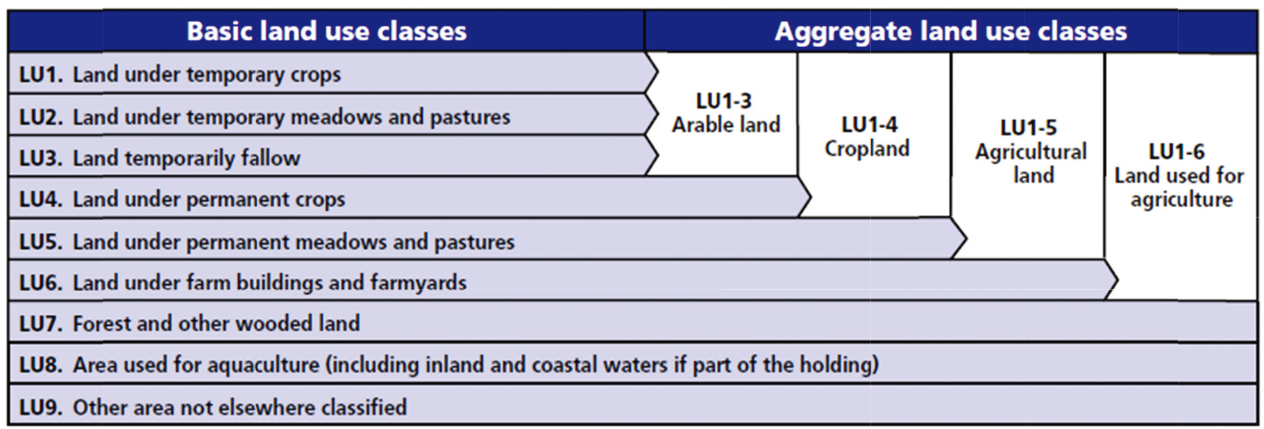
Figure 1.
Classification of land use (WCA 2020).
Section 2 provides a definition of the indicator and a discussion of the key data inputs needed for its estimation. The status of data availability of the indicator based on information in the July 2022 version of the SDG Global Database44 is provided here. Section 3 highlights results of the FAO-UN Women partnership initiative. The instruments and protocols used were aligned to those developed and employed in parallel capacity development initiatives supported by FAO. These are the 50x2030 Initiative to Close the Agricultural Data Gap55 and the integrated land tenure module66 for joint and harmonized data collection of indicators 5.a.1 and 1.4.2.77 These two are well documented in [1, 2, 3, 4], respectively, and are briefly described here. All three collectively aim to contribute, in a coordinated and collaborative fashion, to increase the data production for 5.a.1 through statistical surveys. Section 3 details initial results from the the UN Women-FAO Support to national statistical systems to report on SDG indicator 5.a.1. Section 4 concludes and indicates ways forward.
2.Indicator SDG 5.a.1- definition, concepts, classifications and data availability
This section defines indicator SDG 5.a.1 and the basic concepts and terms. Details are included in the Annex which is based on the official metadata for the indicator [5].
2.1Definition and concepts
The indicator consists of two sub-indicators.
Sub-indicator 5.a.1 (a):
Sub-indicator 5.a.1 (a) measures the prevalence of people in the agricultural population with ownership or secure rights over agricultural land, disaggregated by sex.
Sub-indicator 5.a.1 (b):
Sub-indicator 5.a.1 (b) focuses on gender parity, measuring the extent to which women are disadvantaged in ownership or secure rights over agricultural land.
Concepts and terms:
The basic concepts and terms essential for computing SDG indicator 5.a.1 are the following:
(1) Agricultural land.
(2) Agricultural household.
(3) Agricultural population.
(4) Ownership or secure rights over agricultural land.
Agricultural land. Land is considered ‘agricultural land’ according to its use. The classes and definitions of land use are based on the classification of land use for the agricultural census recommended by the World Programme for the Census of Agriculture 2020.88
As shown in Fig. 1, agricultural land is a subset of the total land of a country. In particular, agricultural land includes LU1–LU5. Since indicator 5.a.1 focuses on agricultural land, it excludes all the forms of land that are not considered for ‘agricultural’ use, namely: LU6–LU9.
Agricultural household. Ownership or secure rights over agricultural land are specifically relevant to individuals whose livelihood relies on agriculture. These individuals are identified by way of whether their household99 can be classified as an agricultural household which for purposes of calculating indicator 5.a.1 is defined as follows:
• At least one member of the household operated land for agricultural purposes or raised livestock over the past 12 months regardless of the final purpose of production.
and
• At least one member of the household operated land for agricultural purposes or raised livestock as an own-account worker.
Agricultural population. The reference population for indicator 5.a.1 is the population of adult individuals living in agricultural households (as defined above). For purposes of international comparability, the recommended definition of “adult” is a person who is 18 years old or older. Once a household is classified as an ‘agricultural household’, all the adult household members are considered as part of the reference population (to be referred to simply as the “agricultural population” in this document).
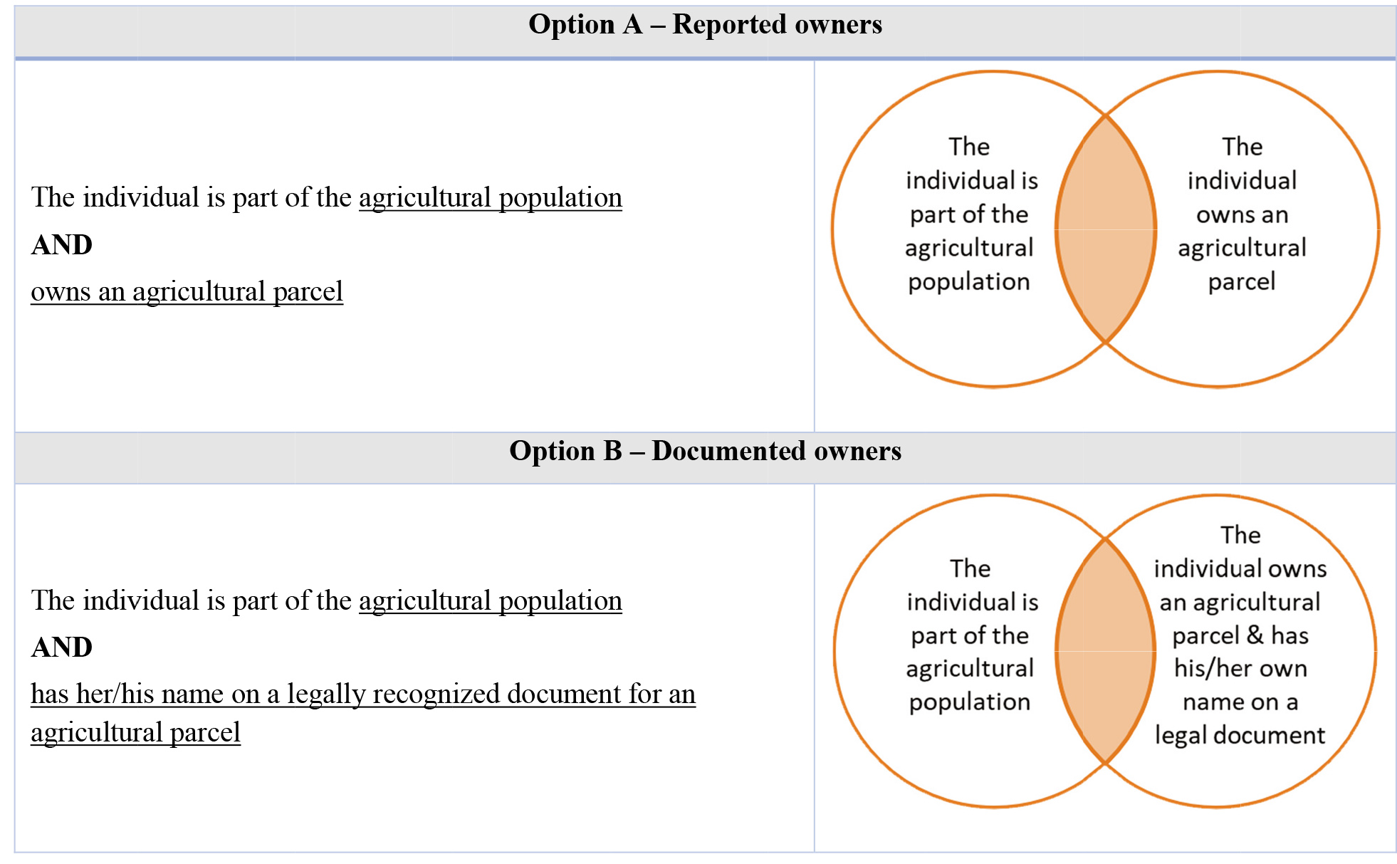
Ownership of agricultural land and secure rights over agricultural land.
To determine whether an individual is said to have ownership or secure rights to agricultural land three conditions (proxies) should be considered:
Formal documentation:
Proxy 1- Presence of legally recognised documents in the name of the individual
Alienation rights:
Proxy 2- Right to sell
Proxy 3- Right to bequeath Agricultural population. The reference population for indicator 5.a.1 is the population of adult individuals living in agricultural households (as defined above). For purposes of international comparability, the recommended definition of “adult” is a person who is 18 years old or older. Once a household is classified as an ‘agricultural household’, all the adult household members are considered as part of the reference population (to be referred to simply as the “agricultural population” in this document).
Ownership of agricultural land and secure rights over agricultural land.
To determine whether an individual is said to have ownership or secure rights to agricultural land three conditions (proxies) should be considered:
Formal documentation:
Proxy 1- Presence of legally recognised documents in the name of the individual
Alienation rights:
Proxy 2- Right to sell
Proxy 3- Right to bequeath
Legally recognized or formal documentation. Proxy 1 refers to the existence of any document that an individual can use to claim property rights before the law over an asset by virtue of the individual’s name being listed as owner/co-owner or holder/co-holder on the document.
Alienation rights. In the absence of formal written documentation alienation rights over land, can serve as a proxy for ownership or secure rights. Alienation is defined as the ability to transfer a given asset during one’s lifetime (Proxy 2- right to sell) or after death (Proxy 3- right to bequeath).
The “right to sell” refers to the ability of an individual to permanently transfer the asset in question in return for cash or in-kind benefits. The “right to bequeath” refers to the ability of an individual to pass on the asset in question to other person(s) after their death.
The official methodology recommends that data on all three proxies be collected for purposes of compiling indicator 5.a.1.
Key challenges in operationalizing the conceptual bases for the indicator.
Based on the work done with countries since 2021 and the development of methods for proxy measures, some challenges have been identified. These include:
1
1. Differentiating the different types of land to ensure that only agricultural land is included. In non-agricultural surveys where questions are included, interviewers would need training to understand the concept of agricultural land.
2. Concept of agricultural household in general agricultural statistical surveys is broader than that used in the definition of 5.a.1. The definition for 5.a.1 requires individual-level information on the employment status and sector of employment of household members.
3. The reference population – the agricultural population – for purposes of compiling 5.a.1 differs from that for general agricultural statistical surveys as a result of the difference in the definitions of agricultural households. A household roster is needed to identify each member of the agricultural population which is not always part of the protocol for agricultural surveys.
4. Definition of and lists of formal documentation. Countries currently do not have a statistical standard that defines the coverage of formal documentation of agricultural land.
5. It is challenging to operationalize the definition of ownership of and secure rights to agricultural land for purposes of data collection. In addition, differences in legal systems and how legal systems protect rights to agricultural land across countries poses challenges in providing comparable statistics across countries.
6. Counting owners of agricultural land requires data at the individual level. The issue of who should provide the data – whether a proxy respondent or the individual directly – has been studied with recommendations for obtaining the data directly from the individual. However, operationally most statistical surveys use proxy respondents.
In Section 3, some options for addressing these challenges drawn from results of country work are indicated.
2.2Indicator availability in the SDG global database
The July 2022 edition of the SDG Global Database includes at least one data point on SDG 5.a.1 for 36 countries from Africa (23), Asia (8), Americas (3), Europe (1) and Oceania (1). The data sources are summarized in Table 1. The indicator values from the Demographic and Health Survey (28) and the Enquete Harmonisee Sur Les Conditions De Vie Des Menages (EHCVM) (6) are proxy measures. The proxy measure methodologies for these two surveys are described in Sections 3.3.2 and 3.3.3, respectively.
Table 1
Data sources of available data on indicator 5.a.1 (July 2022)
| Country | Year | Household surveys (lsms-type) | Agricultural surveys | Demographic and health surveys (DHS) | Enquete harmonisee sur les conditions de vie des menages (EHCVM) | Other |
|---|---|---|---|---|---|---|
| Afghanistan | 2015 | DHS | ||||
| Albania | 2017 | DHS | ||||
| Armenia | 2015 | DHS | ||||
| Benin | 2017 | DHS | ||||
| 2018 | EHCVM | |||||
| Burkina faso | 2014 | Enquête multisectorielle Continue | ||||
| 2018 | EHCVM | |||||
| Burundi | 2016 | DHS | ||||
| Cambodia | 2009 | Household socio-economic Survey | ||||
| 2014 | DHS | |||||
| Cameroon | 2015 | DHS | ||||
| 2018 | DHS | |||||
| Chad | 2014 | DHS | ||||
| Côte d’ivoire | 2018 | Enquête multisectorielle Continue | ||||
| Ethiopia | 2014 | Ethiopian rural Socio-economic survey | ||||
| 2016 | DHS | |||||
| 2019 | Ethiopian rural Socio-economic survey | |||||
| Ghana | 2017 | Agricultural survey | ||||
| Guatemala | 2014 | DHS | ||||
| Guinea-bissau | 2018 | EHCVM | ||||
| Haiti | 2016 | DHS | ||||
| India | 2012 | India human development survey | ||||
| 2015 | DHS | |||||
| Indonesia | 2017 | DHS | ||||
| Lesotho | 2014 | DHS | ||||
| Liberia | 2020 | DHS | ||||
| Malawi | 2013 | Integrated household panel Survey | ||||
| 2015 | DHS | |||||
| 2017 | Fourth integrated Household survey | |||||
| 2020 | Fifth integrated household Survey | |||||
| Mali | 2018 | DHS | ||||
| Myanmar | 2015 | DHS | ||||
| Nepal | 2016 | DHS | ||||
| Niger | 2011 | National survey on household and living conditions | ||||
| 2014 | National survey on household and living conditions | |||||
| 2018 | EHCVM | |||||
| Nigeria | 2013 | General household survey Panel-wave 2 | ||||
| 2016 | General household survey Panel-wave 3 | |||||
| 2018 | DHS |
|
Table 1, continued | ||||||
|---|---|---|---|---|---|---|
| Country | Year | Household surveys (lsms-type) | Agricultural surveys | Demographic and health surveys (DHS) | Enquete harmonisee sur les conditions de vie des menages (EHCVM) | Other |
| 2019 | General household survey Panel-wave 4 | |||||
| Peru | 2014 | Encuesta nacional Agropecuaria | ||||
| 2016 | Encuesta nacional Agropecuaria | |||||
| 2017 | Encuesta nacional Agropecuaria | |||||
| 2018 | Encuesta nacional Agropecuaria | |||||
| Rwanda | 2014 | DHS | ||||
| Senegal | 2018 | EHCVM | ||||
| 2019 | DHS | |||||
| Sierra leone | 2019 | DHS | ||||
| Togo | 2018 | EHCVM | ||||
| Uganda | 2016 | DHS | ||||
| 2018 | Annual Agricultural Survey | |||||
| United republic Of tanzania | 2009 | National panel survey | ||||
| 2011 | National panel survey | |||||
| 2013 | National panel survey | |||||
| 2015 | National panel survey | |||||
| 2016 | DHS | |||||
| Zambia | 2018 | DHS | ||||
| Zimbabwe | 2015 | DHS | ||||
3.Partnerships for SDG indicator 5.a.1
This section describes work done by FAO, the custodian agency of SDG indicator 5.a.1, in partnership with other UN Organizations, to promote and strengthen the country capacity to collect data for the generation of 5.a.1.
3.1The 50x2030 initiative to close the agricultural data gap
The 50x2030 Initiative to Close the Agricultural Data Gap is a multi-agency effort that addresses current shortcomings in the quality and persisting gaps in the availability of agricultural data. The strategy is to transform country data systems in 50 countries in low- and lower-middle income countries to enable them to produce fundamental agricultural and rural data through the use of integrated household and agricultural surveys by 2030. This initiative is implemented through a unique partnership between the World Bank, the Food and Agriculture Organization of the United Nations and the International Fund for Agricultural Development. For more information on the 50x2030 Initiative, refer to [1, 2, 3].
As detailed in [2], to achieve stronger agricultural and rural data systems, activities are designed around three interrelated components – development of tools and methods, data production and data use. In particular, the development of tools and methods and data production activities prioritize the production of SDG priority indicators, among which is SDG 5.a.1. Key methodological approach is the conduct of integrated survey programs – an Agricultural Survey Programme and an Integrated Agricultural and Rural Survey Programme. The Agricultural Survey Programme collects data through integrated questionnaires (the Farm Income, Labor, and Productivity Questionnaire and the Non-Farm Income and Living Standards Household Questionnaire) that allows for the production of SDG indicators 1.4.2, 2.3.1, 2.3.2, 2.4.1 and 5.a.1 every three years [2, 3].
A guide to incorporating the data requirements for indicator 5.a.1 into its standard survey tools has prepared a guide [6] that describes the 50x2030 survey system, explains which questionnaires include SDG indicator 5.a.1 questions, and provides an overview of these questions.
Through the Annual Agricultural Surveys conducted in 2018 and 2019, Uganda has produced estimates of the SDG 5.a.1 sub-indicators [4]. With 50x2030 support, Senegal and Cambodia will have estimates based on the data collections undertaken from 2021 onwards.
3.2Joint survey instrument for SDG indicators 5.a.1 and 1.4.2
As described in Section 2, SDG indicator 5.a.1 measures gender equality in ownership and secure tenure rights over agricultural land. SDG indicator 1.4.2 also measures tenure security through two sub-indicators – certification of tenure rights through legally recognized documents and security of tenure through a ‘perception-based’ measure The differences between the two indicators are: indicator 1.4.2 considers all types of land, regardless of their use; it covers the entire adult population; and measures tenure rights with legal documents and perceptions. However, the indicators when taken together provide a range of statistics on individual-level land tenure rights and associated tenure security, disaggregated by sex. In addition, these share similar data requirements.
In order to benefit from this overlap, by supporting integrated and cost-effective data collections, the custodian agencies of the two indicators (FAO for 5.a.1; World Bank and UN-Habitat for 1.4.2) worked together on a harmonized questionnaire instrument to collect the data required for both indicators simultaneously. The instrument is designed for integration into nationally representative surveys – both non-agricultural and agricultural household surveys (e.g., budget surveys, Living Standards Measurement Survey, Multiple Indicator Cluster Survey, Demographic and Health Survey). Recommended five versions are described in [7]. The module has been integrated into the package of standard modules of the 50x2030 initiative; the questions for both indicators have been integrated in some of the most recent LSMS-Integrated Surveys on Agriculture surveys, with adaptations to fit the structure of the surveys, namely in the surveys collected in Tanzania, Malawi, Ethiopia and Nigeria.
Table 2
Data collection vehicles analyzed for the collection of data for SDGi 5.a.1 (Recommended data collection vehicle are highlighted in italic)
| Data collection vehicle | |||||||
|---|---|---|---|---|---|---|---|
| Country | Agricultural census | Agricultural survey | Population census | Labour force survey (LFS) | DHS/MICS* | Other household surveys | Others |
| Bangladesh | Agriculture Samplecensus | ||||||
| Bolivia | Agricultural Census | National Agricultural Survey | |||||
| Chile | National Agriculturaland Forestrycensus | Intercensal Agricultural Surveys | CASEN Household Survey | ||||
| Fiji | Fiji agriculture Census | Population and Housing census |
| ||||
| Kiribati | Agricultural Census | Agricultural Survey | Population and Housing census | MICS – Social development Indicator Survey | Household Income and Expenditure Survey | ||
| Mongolia |
| Women Herders Survey | Labour force Survey (LFS) |
| Establishment Census | ||
| Philippines | Census ofAgriculture and Fisheries (CAF) | Labour force Survey (LFS) With rider Annual Poverty Indicator Survey (APIS) | Community-based Monitoring System (CBMS) | ||||
| Samoa | Agriculture Census | Census of Population & Housing | Labour force And school-to-work Transition Survey | DHS-MICS |
| ||
| Solomon islands | National Agriculture Census | National Agriculture Survey | Population and Housing Census | Labour force survey | DHS-MICS | Household income and expenditure survey | |
| Tonga | National Agriculture Census | Population and Housing census | MICS | ||||
*DHS refers to demographic and health survey and MICS refers to multiple indicator cluster survey.
Table 3
Details on recommended data collection vehicles for collecting data for SDGi 5.a.1
| Country | Recommended data collection vehicle |
|---|---|
| Bangladesh |
|
| Bolivia |
|
| Chile |
|
| Fiji |
|
| Kiribati |
|
| Mongolia |
|
| Philippines |
|
|
Table 3, continued | |
|---|---|
| Country | Recommended data collection vehicle |
| Samoa |
|
| Solomon Islands |
|
| Tonga |
|
3.3UN Women-FAO Partnership on SDG 5.a.1
In 2020, UN Women and FAO commenced collaborating in providing support to countries to accelerate the increase in the number of national statistical systems (NSSs) who produce or are in a position to produce estimates of SDGi- 5.a.1 in 2021–2022 and, in addition, increasing the number of NSSs who have the capacity and are in a position to produce estimates during the period 2023–2025. The strategy is to assist the National Statistical Offices (NSOs) and other relevant national institutions (including ministries of agriculture and women) responsible for producing and using official statistics in general, and SDG indicator 5.a.1 in particular, to apply the internationally recommended methodology and prepare technical and action plans for mainstreaming data collection for estimating the indicator in an existing appropriate data collection vehicle.
In addition to strengthening capacity for direct data collection and estimation of SDG 5.a.1, the strategy also called for generating proxy measures from existing data sources as an interim solution. By analyzing the data sources and producing best possible proxy measures from these, the exercise could give rise to recommendations on how they can better integrate the data requirements for 5.a.1 to meet the data requirement more closely for 5.a.1.
It is worth noting that the work that has been done for producing proxy measures has proven to valuable not only for the obvious effect of increasing the number of countries for which it is possible to estimate the indicator, but also for the thinking exercise that has helped surface some issues that might come up when tailoring the indicator’s questions to existing data collection instruments. The proposed improvements of the existing questionnaires also provide a new set of questionnaire modules that could be adapted for data collection instruments that are not specifically designed for the purpose of collecting data on land ownership.
3.3.1Country studies on assessing potential of existing data collection vehicles for producing data for SDG 5.a.1 estimation
The FAO-UN Women partnership carried out technical reviews of the data systems of ten (10) countries with the aim of identifying suitable data collection vehicle/s for integrating the data requirements of 5.a.1. With recommendations for a technical design (survey/census, questionnaires, respondent selection) for integrating 5.a.1 data requirements in the proposed data collection vehicle from existing surveys/censuses and a protocol for testing the proposed design, Mongolia integrated the questions in their 2022 Census of Agriculture and the Philippines is piloting a questionnaire for data collection on the indicator in their forthcoming census of agriculture. Bolivia has piloted one for an agricultural survey. These experiences are now being applied to develop census of agriculture questionnaires that integrate data collection for 5.a.1 in some Caribbean countries. Tables 2 and 3 present a summary of the surveys/censuses reviewed and the recommended data collection vehicle/s for each of the 10 countries.
In terms of recurring themes, the country studies showed the following:
• To fast track the production of baseline estimates for 5.a.1, the practical solution is to use the upcoming data collection activities. These are usually the agricultural census (the 2020 World Census of Agriculture Programme), and regular or upcoming agricultural surveys.
• For more regular monitoring, an approach which uses a larger instrument like an agricultural census to estimate a baseline and then lighter surveys like agricultural or general household surveys for subsequent data points has been recommended for several countries.
• Adapting agricultural data collection instruments often requires the integration of a household roster to collect details on household members, in order to identify the relevant agricultural population to compute the indicator values according to the indicator methodology. The metadata document [5] shows how this may be done using the parcel approach. The Philippines (to be tested in mid-2022 in the forthcoming Census of Agriculture) and Mongolia (ongoing Census of Agriculture) have integrated household rosters in the questionnaires. Chile and Bolivia are studying the feasibility to integrate the module in intercensal surveys.
• Regularly (in place or planned) conducted non-agricultural household surveys focusing on specific topics such as the LFS, DHS or MICS or multi-purpose surveys such as the Harmonized Living Conditions Surveys (EHCVM) conducted in the 8-country West African Economic and Monetary Union through partnership with the World Bank make these surveys strong candidates for regular monitoring purposes. However, efficient ways of integrating the data required for the production of 5.a.1 in these surveys need to be developed. Indications of how these can be done for the DHS and the EHCVM are discussed in the next section.
• In the absence of short- to medium- term plans for regular data collection, ad hoc surveys may need to be considered, such as the Gender and Environment Survey for Samoa described in Table 2.
With this information, knowledge products are being developed for dissemination to further accelerate the take-up of data collection and estimation of 5.a.1 by countries.
Besides recommendations for which data collection instruments are most suited for collecting data for 5.a.1 in the specific context of each country, these country studies have resulted also in concrete proposals for modules to be integrated in national data collections and in action plans outlining how to implement the recommendations. More specifically, for all the countries involved a proposal for a specific tailored module has been developed; for the two countries that had the closest upcoming suitable data collections, the Philippines and Mongolia, specific action plans for implementations have been prepared.
3.3.2Proxy measures from demographic and health surveys
This section presents the proxy measure methodology developed for an initial set of Demographic and Health Surveys phase 7 (DHS-7)1010 survey data and documents the limitations of the proxy measure in terms of how the existing data deviates from the official recommendations.
The discussion focuses on the questions from which data requirements for 5.a.1 are derived. It is to be noted that there are, in general, other factors that need to be considered in order for a non-agricultural survey such as the DHS be suitable for estimating 5.a.1. These factors include the representativeness of the sample in terms of covering agricultural activities and households (e.g., nationally representative includes urban and rural areas on a random basis) and covering the working age population for both the women and men samples. A sample that includes only married couples, for example would be far from representative in terms of 5.a.1 requirements.
The DHS-7 surveys
The DHS Program has collected, analyzed, and disseminated accurate and representative data on various topics including population, health, HIV, nutrition, women’s economic empowerment and violence against women through more than 400 surveys in over 90 countries since its inception.
This study focuses on the DHS-VII surveys which were fielded starting in 2018. For the calculation of SDG indicator 5.a.1, the sources for the minimum data requirements are specific data items from the three questionnaires of the survey, briefly described below:
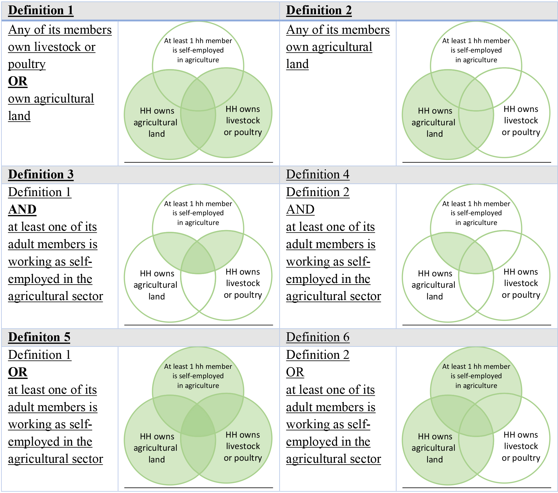
Figure 2.
First six definitions of agricultural households.
• Household Questionnaire (HQ) is used to list all the usual members and visitors in the selected households. Some basic information is collected on the characteristics of each person listed, including their age, sex, and whether the household owns livestock and poultry or owns agricultural land.
• Woman Questionnaire (WQ) is used to collect data on background characteristics (Section 1), employment and gender roles (Section 9) for information on the main occupation of the individuals to identify those who are self-employed in agriculture as well as individual ownership of land (non-agricultural and agricultural land are aggregated).
• Man Questionnaire (MQ) similar to but shorter than the Woman’s Questionnaire, is used to collect data on background characteristics (Section 1), employment and gender roles (Section 6), for information on the main occupation of the individuals to identify those who are self-employed in agriculture as well as individual ownership of land (non-agricultural and agricultural land are aggregated).
Identifying the agricultural population using DHS data
For the denominator of 5.a.1, we need to identify the agricultural population, which is defined as “adult individuals living in households where at least one member is involved in agriculture as an own account/self-employed worker”. Thus, the first step is to identify the agricultural households, where someone in the last year has cultivated any land or raised any livestock or poultry. Although the DHS-VII questionnaire does not explicitly collect this information, there are three pieces of information that could be used for this purpose:
1
1. Whether the household owns any agricultural land (HQ)
2. Whether the household owns any livestock or poultry (HQ)
3. Employment information of interviewed individuals to identify those who are self-employed in agriculture (WQ and MQ)
Household level ownership of land and/or livestock (1 and 2) is not sufficient to identify those who have been working in agriculture, thus these two are complemented by taking into account the working sector and status of interviewed individuals (3).
Initially, FAO identified 6 possible definitions derived from the three dimensions above, in which the household level ownership of agricultural land was always taken into account and combined with the other two to find a suitable proxy. These six options are summarized in Fig. 2.
The rationale behind always including the household level ownership of agricultural land as a criterion in the denominator was to mitigate an issue with the numerator, which will be further discussed later. In short, individual questions on land ownership (used for the numerator) are not specific to agricultural land, but refer to any land, thus restricting the denominator to only households with ownership of agricultural land in particular would have helped in improving the proxy.
After these six initial definitions, internal discussions led to the idea that the household ownership of agricultural land could also be moved from defining the agricultural households of the denominator to help discerning individual general landowners from individual agricultural landowners at the numerator level. In other words, instead of restricting the denominator only to households who have some agricultural land (as well as one or two of the two other criteria), we could restrict the numerator only to individuals in agricultural households who possess land themselves and that live in a household with ownership of agricultural land. This opened up to the possibility of 4 further definitions for the denominator, which did not necessarily account for household agricultural land ownership at this stage, these are summarized in Fig. 3.
Figure 3.
Four additional definitions of agricultural households.
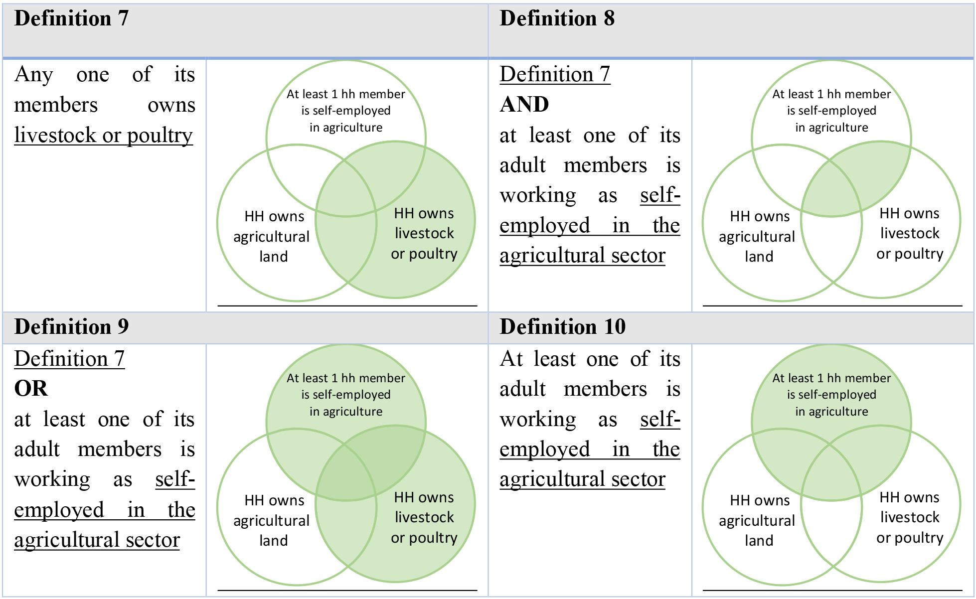
Figure 4.
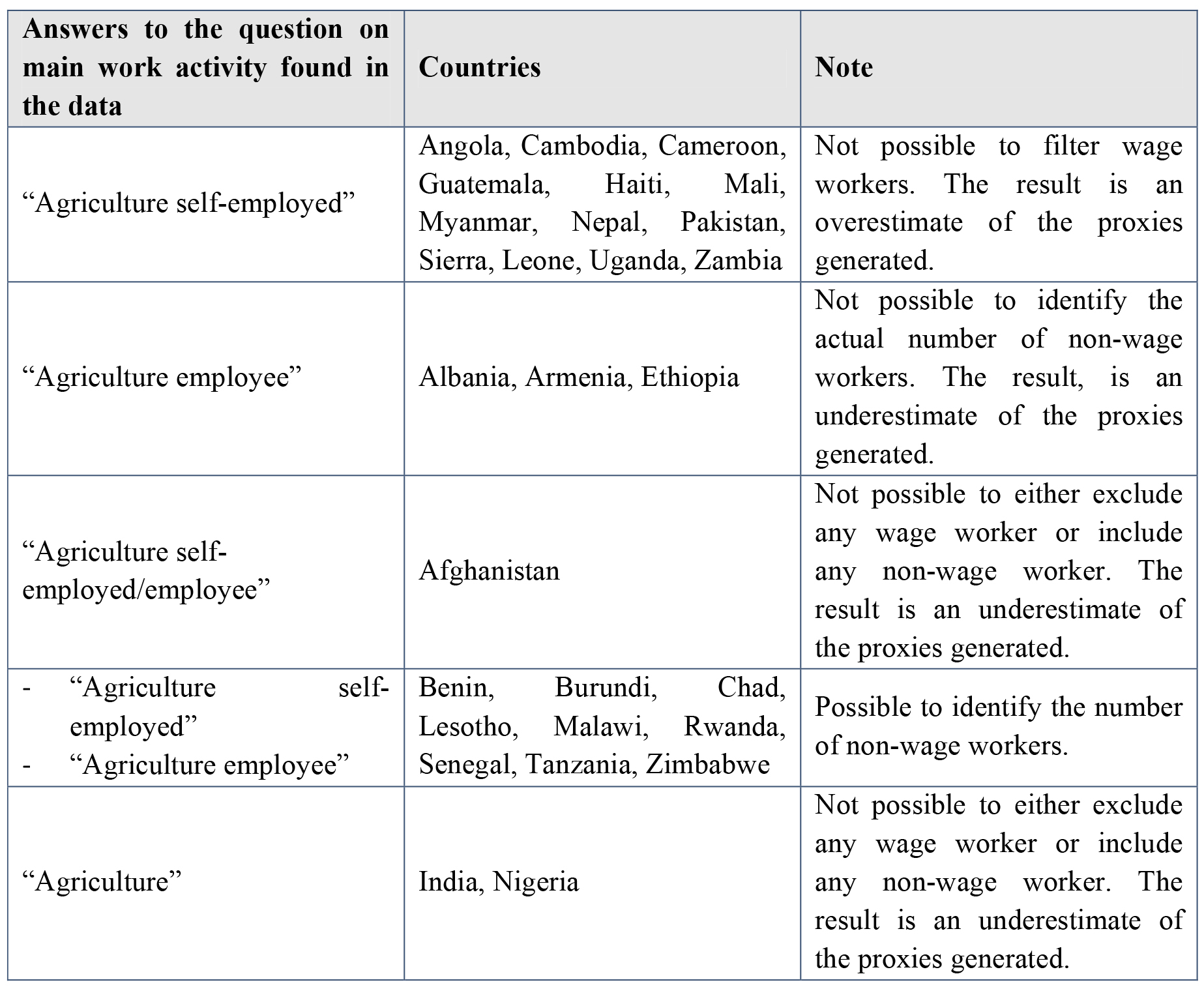
Different types of answers to main work activity found in the data and corresponding limitations.
On review, the closest definition to the metadata would be definition 10, which looks at the individual employment sector and status of the men and women, which is found in the questionnaire usually administered to individuals between 15 and 49 years of age. Thus, any household where at least one of the interviewed members is classified as self-employed in agriculture has been identified as an agricultural household. In turn, any adult (18
How women’s and men’s employment information are collected in the DHS
The indicator’s metadata recommends including households where the involvement in agriculture is through self-employment activities at least for one of the members. Thus, it is recommended to filter out the households where all the members that are involved in agriculture are wage workers. Usually, this is achieved by adding another question that specifically asks for the type of employment. However, we do not have precise information on this distinction in the men’s questionnaire of the DHS dataset. In fact, although the women’s questionnaire includes the question: “Do you do this work for a member of your family, for someone else, or are you self-employed?”, the question is not present in the men’s questionnaire in all the countries analyzed except for Indonesia.
Despite the inconsistency between the two questionnaires, it is possible to retrieve the employment status of men by analyzing the answers to the question on the main work activity in the men’s questionnaire. Unfortunately, the answers to this last question were not collected uniformly across all countries, leading to inconsistency in the responses as summarized in Fig. 4.
Implications of the choice of denominator for the estimation using DHS data
The choice of denominator definition has important implications in terms of the sample that can be used to estimate the proxy for SDGi 5.a.1. In the DHS, household level information is collected through the household questionnaire that is administered to all sampled households. Individual level information is collected through the women’s questionnaire, which is administered to all eligible women in all households; and through the men’s questionnaire, administered to all eligible men in a subsample of households, usually one half or one third.
Whenever we use individual employment information to define agricultural households, and thus we use individual data to define household level characteristics, i.e., definitions 3, 4, 5, 6, 8, 9 and 10, if we estimate the indicator on the whole sample, there will be a bias between households where both men and women have been interviewed and those households where only women have been interviewed. The proxy measure methodology thus uses a subsample of the survey households consisting of households where both men and women are interviewed.
Identifying the agricultural landowners using DHS data
The numerator of indicator 5.a.1 is defined as the number of people in agricultural population with ownership or secure rights over agricultural land. To determine whether an individual is said to have ownership or secure rights to agricultural land three conditions (proxies) are defined in the indicator’s metadata:
Proxy 1. Presence of legally recognized documents in the name of the individual (formal documentation).
Proxy 2. Right to sell (1
Proxy 3. Right to bequeath (2
Including alienation rights is necessary to include de facto ownership in the indicator, which is especially relevant in countries where the penetration of formal documentation is low but individuals still hold customary and non-formal ownership rights.
The collection of land ownership information in the DHS survey differs from the recommended methodology for 5.a.1. The DHS questionnaire has three questions that relate to individual land ownership, that are administered through the male and female individual questionnaire:
1
1. Individual reported land ownership: “Do you own any agricultural or non-agricultural land either alone or jointly with someone else?”, where the individual self-identifies as the owner.
2. Individual reported land ownership documentation: “Do you have a title deed for any of the land you own?”, where the individual declares both owning any land and possessing a title deed on any of the land, but it is not known whether their name is on the document.
3. Individual documented land ownership: “Is your name on the title deed?”, where the individual declares to both own any land and has their name on a legally recognized document. This is the question that is closest to proxy 1 of SDGi 5.a.1. [Proxy 1]
Thus, these three questions posed a few challenges in terms of estimating 5.a.1. First of all, individual land ownership questions do not refer specifically to agricultural land, but they refer to any type of land; this challenge was mitigated by taking into consideration the household level question that was specific on agricultural land ownership:
4. Household reported agricultural land ownership: “Does any member of this household own any agricultural land?”, which is found in the household questionnaire.
Only individuals who declared having any type of land and at the same time lived in a household that owned agricultural land were considered for the indicator’s numerator.
Secondly, no alienation rights data are collected, which could imply a significant loss of information on individuals who might be the de facto owners and exercise ownership rights even if they do not have a document.
Given the above discussion, three different approaches for the calculation of the numerator were evaluated based on the availability of proxies in the DHS as described in Fig. 5.
Figure 5.
Three definitions of agricultural landowners.
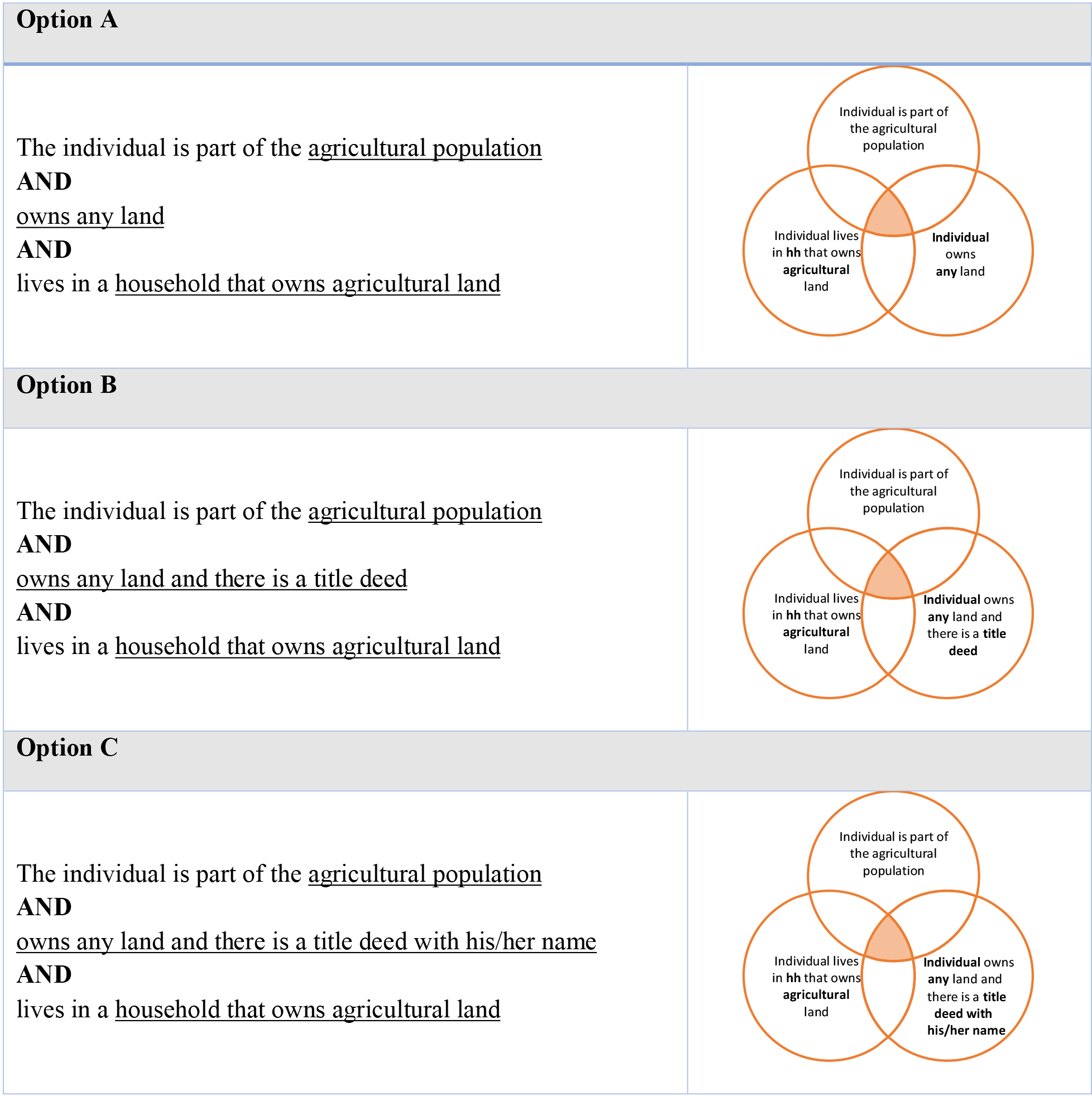
Whenever the three proxies are not available, the recommendation from 5.a.1’s methodology is to prefer the most inclusive option, to include non-formal and customary forms of ownership. Using option B or option C would mean to exclude many situations where non-formal but de facto ownership is relevant to women’s and men’s empowerment. Thus, option A has been selected as the one providing the best approximation of SDGi 5.a.1.
Recommendations for including SDGi 5.a.1-specific questions into DHS
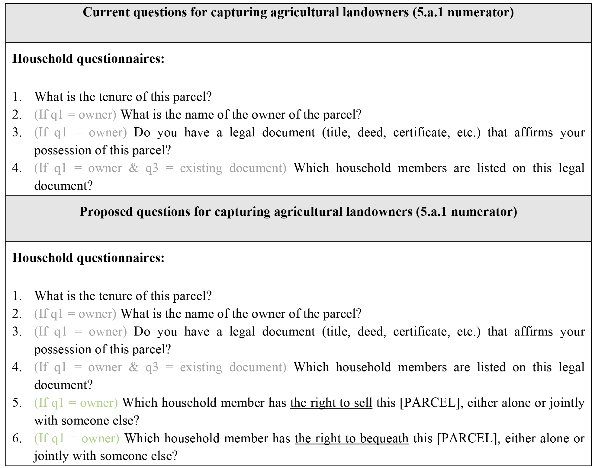
DHS surveys have the potential to be a valuable source of data to estimate SDGi 5.a.1. The discussion in this paper has touched upon how the available data can be used to approximate the estimate of the indicator, albeit with a few important limitations. Some can be easily solved and some are more difficult to overcome – for instance the fact that relevant questionnaires are administered to an age-defined subset of the population (usually 15–49 years, for example, for women). We would like to offer some recommendations on how to revise the existing DHS questionnaire to include all the data requirements to estimate SDGi 5.a.1.
The main limitation to the identification of the denominator, i.e. the agricultural population, lies in the different ways employment questions are collected for men and for women. Collecting a question regarding the type of employment (whether the individual works for a family member, for someone else or is self-employed) not only for female respondents but also for male respondents would eliminate this issue. The proposal for improvement would simply entail adding one question in the male questionnaire to reflect the same structure as the female questionnaire, as layed out in Fig. 6, where the proposed addition is highlighted in green.
Figure 6.
Proposal for improving questions capturing the agricultural population according to 5.a.1 definitions.
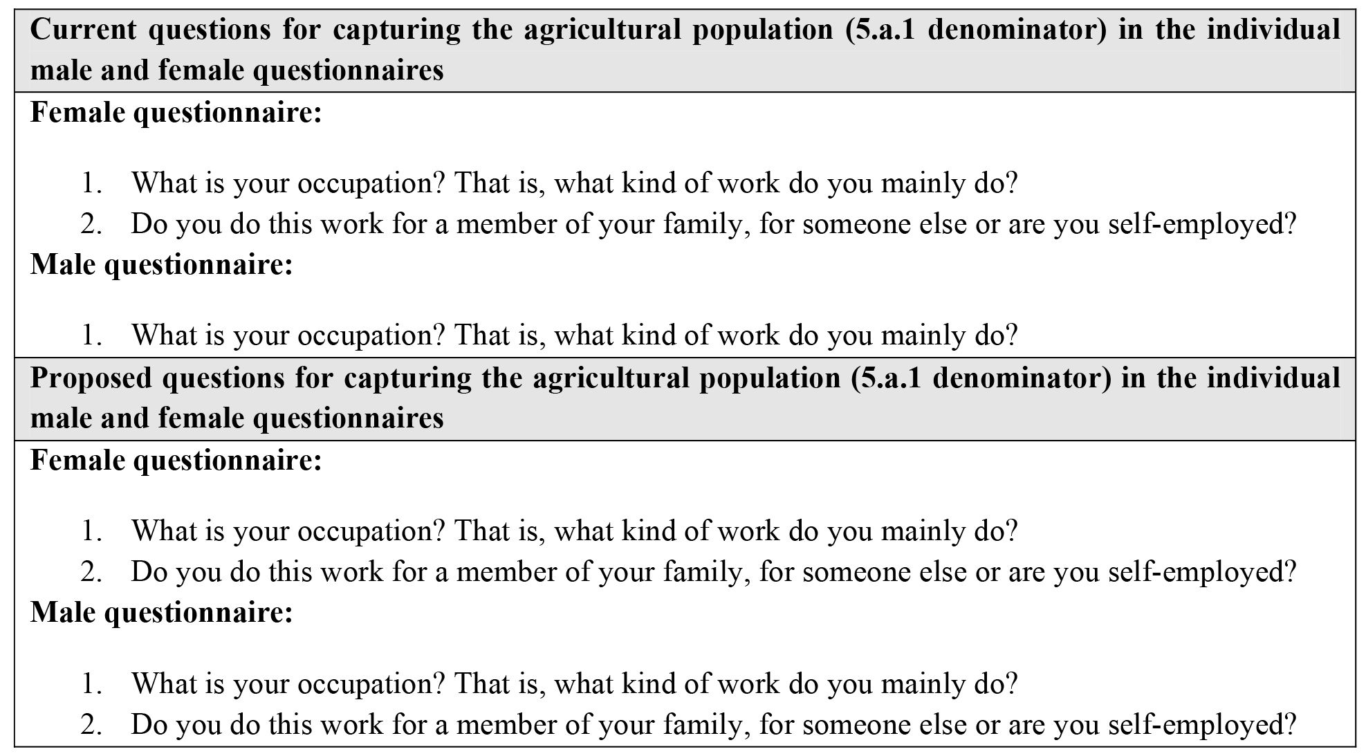
Figure 7.
Proposal for improving questions capturing land ownership according to 5.a.1 definitions.
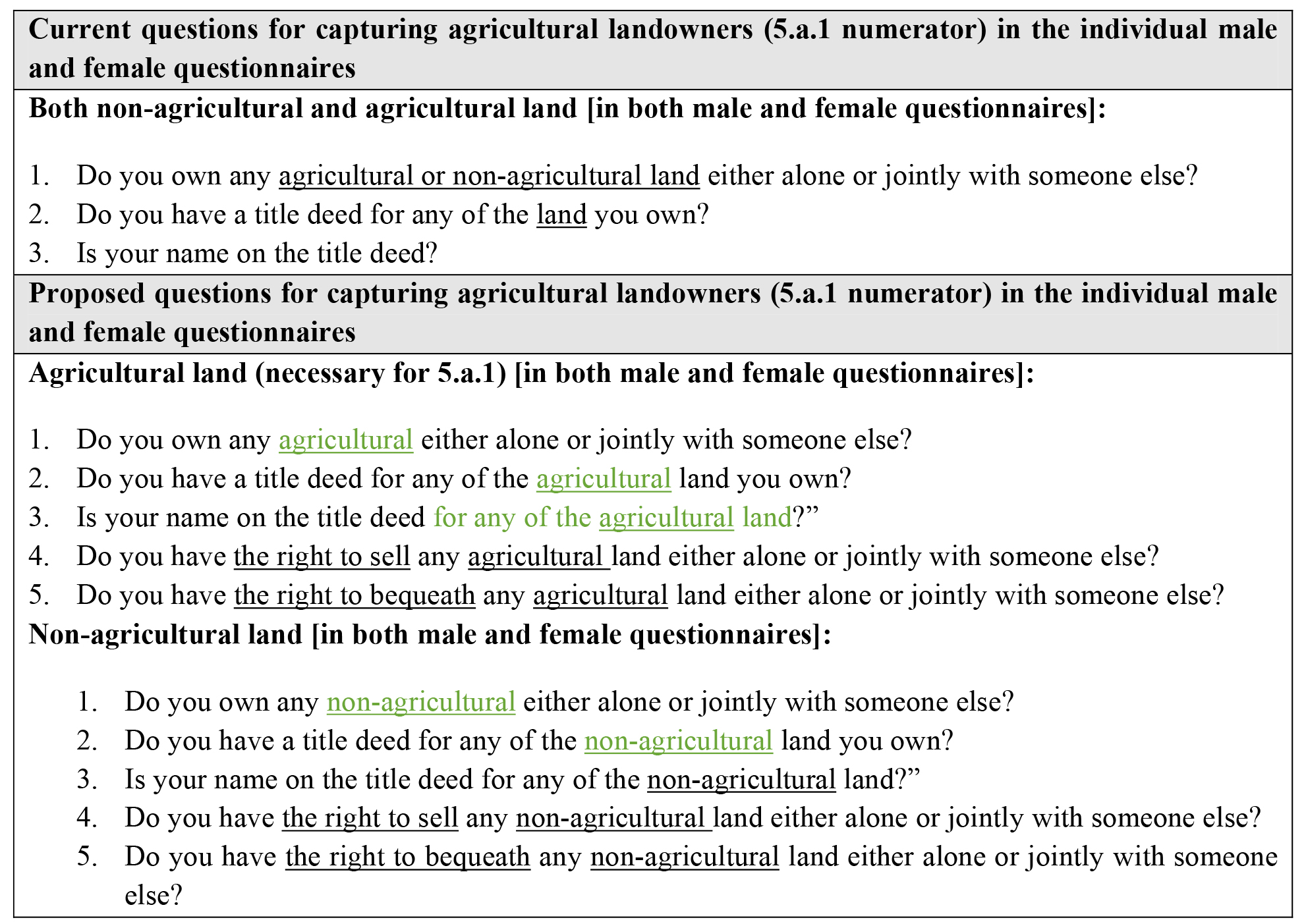
In terms of the numerator, there are two main limitations. First, land ownership questions are not specifically referring to agricultural land, but rather refer to both non-agricultural and agricultural land together. Asking the same 3 existing questions separately for non-agricultural and agricultural land would allow to identify agricultural landowners and discern them from other types of landowners. The second limitation is found in the lack of questions on alienation rights, which means that the survey does not capture a very important section of de-facto ownership, which proves particularly relevant for female landownership in many countries; within the flow of the current questionnaire, this dimension could be easily captured by adding two questions for each type of land that is collected. The proposal is layed out in Fig. 6 where changes and additions are highlighted in green.
The two proposals in Figs 6 and 7 provide a simple and effective way to align the current questionnaires to the SDGi 5.a.1 recommended methodology which allows for a good estimation of the indicator. Individual countries may wish to expand on this proposal and add questions on the type of land ownership, to be able to disaggregate the indicator by type of tenure, for instance freehold tenure, customary tenure and so on. Such an exercise would need to be preceded by an analysis of the existing land tenure system in the country and corresponding adaptation of the questionnaire. Then, a question on the type of tenure should follow question 1 of proposal 7, and questions 2–5 should be repeated for each type of tenure.
3.3.3Proxy measures from the EHCVM
The eight member states1111 of the West African Economic and Monetary Union (WAEMU) have conducted a project in collaboration with the World Bank to harmonize and modernize living conditions surveys. As a result, in 2018, each of the eight countries conducted the Enquête Harmonisée sur les conditions de vie des ménages (EHCVM)1212 or Harmonized Living Conditions Surveys.
The harmonized household questionnaire is wide ranging, as it collects information on the socio-demographic characteristics of household members, education, general health, employment and other income, savings and credit, food consumption and security, household expenditures, non-agricultural enterprises, housing, household assets, transfers, shocks and coping strategies, safety nets, agriculture, fishing and subjective poverty.
For the calculation of SDG indicator 5a1, the EHCVM surveys’ potentially relevant sections of the questionnaire are:
Section 1: Socio-demographic characteristics of the household, for information on the age and sex of the individuals.
Section 4: Employment, for information on the main and secondary occupation of the individuals to identify those who are self-employed in agriculture.
Section 16A: Fields and parcels, for information on the household’s engagement in agriculture as well as on the individual ownership of agricultural land.
Section 17A: Livestock, for information on the household’s engagement in livestock raising activities
Identifying the agricultural population using EHCVM data
With reference to the key requirements for estimating indicator 5.a.1 and its sub-indicators, the EHVCM collects three types of information that could be used to identify agricultural households:
1
1. Employment data of individual household members (Section 4 – employment).1313
2. Whether at least one member of the household has cultivated any land during the winter season (Section 16A – fields and parcels).1414
3. Whether at least one member of the household owned or raised any livestock in the past 12 months (Section 17A – livestock)1515
There are three main challenges in identifying the denominator arising from this structure of the EHVCM survey questionnaire:
Figure 8.
Operational definition of agricultural households for 5.a.1 in EHVCM surveys.
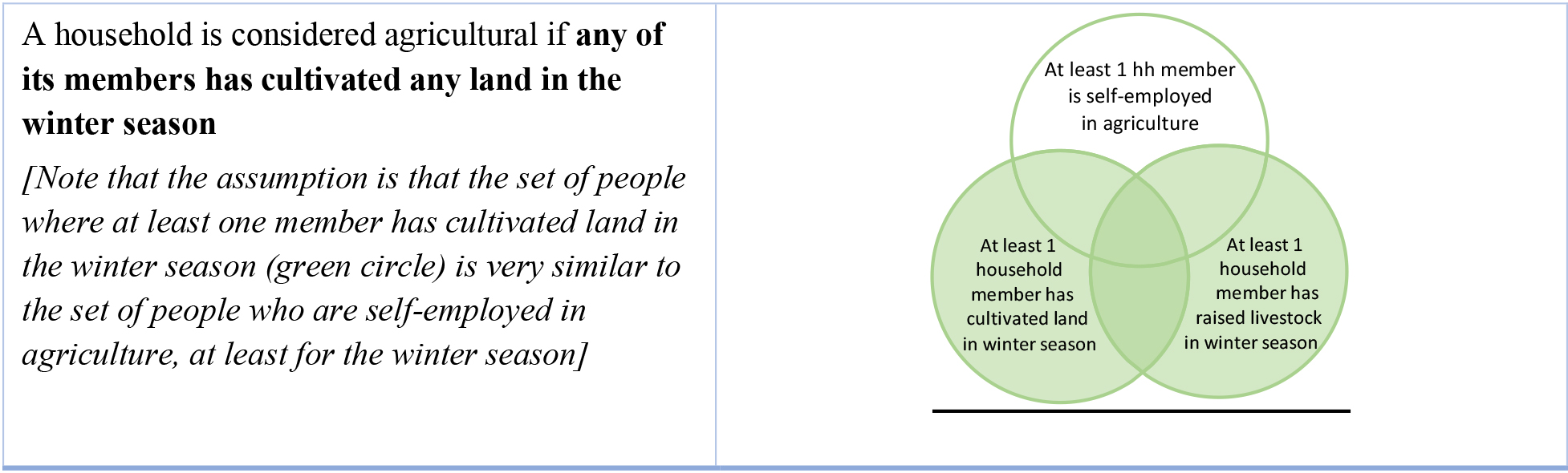
First of all, although it fits the definition, Section 17A cannot be used for purposes of identifying the denominator of SDG indicator 5.a.1. The reason is that the individual ownership questions are located in the “fields and parcels” (Section 16A) section of the survey, and thus they are administered only to households that have been identified as cultivating land. Livestock-only households cannot be included in the denominator because their members’ numerator status is undefined since they are not asked about their ownership of land. Thus, the proxy for 5.a.1 estimated using this survey will have the limitation of having a denominator and thus a reference population restricted to crop farming households only.
Secondly, the question in Section 16A that identifies households where at least one member has cultivated land has a shorter reference period, the winter season, than recommended by the indicators’ metadata, the past 12 months, and this represents a limitation of the estimate computed using these surveys.
And thirdly, although Section 16A does not explicitly consider only individuals who are self-employed in agriculture, it still implicitly does so by collecting information based on a roster of parcels cultivated by the household. The tenure options of these parcels are: owner, free loan, tenant farming, sharecropping, pledge or other, clearly indicating that agricultural wage workers are not captured by this section. For simplicity, it was decided not to use employment information from Section 4 to further confirm whether they were self-employed. Households that are self-employed in agriculture in Section 4 but at the same time they are not captured in Section 16A will still be excluded given that they were not asked ownership questions. Households who are involved in agriculture exclusively through wage work would not be captured by Section 16A in the first place.
Given the challenges and considering the limitations above, only adult individuals who live in households who declare cultivating land in Section 16A were included in the denominator of 5.a.1, the main driver of this decision was the placement of ownership questions only in that section. For a visualization of this operational definition, refer to Fig. 8.
Figure 9.
Two definitions of agricultural landowners in EHCVM surveys.
Identifying the agricultural landowners using EHCVM data
As defined in Section 2, to capture the individual ownership of agricultural land, the methodology for SDG indicator 5.a.1 recommends identifying individual land ownership through the collection of the three proxies of ownership rights. Collecting data on alienation rights allows to capture the de facto owners of agricultural land even in contexts where legal documentation is not widespread.
Figure 10.
Proposal for improving questions capturing land ownership in EHCVM surveys according to 5.a.1 definitions.
After having identified the data source of the denominator, i.e. the agricultural population, we need to identify the data source for the numerator of 5.a.1, namely the adult men and women in the agricultural population who are owners of agricultural land. Individual ownership of agricultural land in EHCVM surveys is collected for each of the parcels listed in the “fields and parcels” section1616. For each parcel declared by the household, respondents are asked four relevant questions regarding the ownership, that allow both for identification of individual reported owners, as well as individual documented owners of the parcels.
• Tenure
1. What is the tenure of this parcel? [1 Owner/2 Free loan/3 Tenant Farming/4 Sharecropping/5 Pledge/6 Other]1717
• Reported ownership (asked only if the tenure is “1 – Owner”):
• Documented ownership (asked only if the tenure is “1 – Owner”):
Do you have a legal document (title, deed, certificate, etc.) that affirms your possession of this parcel? [1 – Land title/2 – Farming permit/3 – Verbal statement/4 – Lease/5 – Sales agreement/6 – Other/7 – None]1919
Which household members are listed on this legal document?2020
These questions allow for two options for the identification of landowners, these two options are visualized in Fig. 9.
Broadly speaking, Option A, reported ownership or possession, is relatively less reliable than Option B, documented ownership. However, in a situation of scarce data on formal documentation along with missing information on alienation rights, reported ownership is a useful alternative for comparing ownership between men and women without excluding de-facto ownership. Thus, in this case individuals identified as being the reported owners (as shown in option A) are considered as owners for the numerator of SDG indicator 5.a.1. Using option B would mean to exclude many situations where non-formal but de facto ownership is relevant to women’s and men’s empowerment.
Which type of land is captured by the EHCVM surveys
It is important to note that an important limitation of EHCVM surveys concerns the identification of agricultural land, as defined in Section 2.
The EHCVM questionnaire asks to list all the field and parcels that have been exploited by someone in the household, thus covering LU1 and LU4; however it does not include pasture land (LU2 and LU5) and fallow land (LU3). Thus, the numerator will be underestimated since the survey does not collect information on some subcategories of agricultural land.
Recommendations for including SDGi 5.a.1-specific questions into EHCVM
EHCMV surveys have the potential to be a valuable source of data to estimate SDGi 5.a.1. The discussion in this section has touched upon how the available data can be used to approximate the indicator, albeit with a few important limitations. We would like to offer some recommendations on how to integrate the existing EHCMV questionnaire to include all the data requirements to estimate SDGi 5.a.1:
1
1. All members of the agricultural population, which includes crop farming and livestock raising households, should be asked about their ownership of agricultural land. At the moment, only the former are captured, thus the recommendation is to create a roster of parcels by asking both Section 16A households (crop farming) and Section 17A (livestock) households in order to collect ownership data. Ideally, it should also include a question to verify that the agricultural work is carried out as own-account work or work for household members and not as salary work.
2. Agricultural land includes also land that is temporarily fallow, as well as temporary and permanent meadows and pastures, thus we recommend including parcels with these 3 types of land use to the roster of parcels collected for ownership data collection. Currently, only parcels with temporary and permanent crops are covered.
3. The reference period for agricultural activities often refers to two seasons, about 12 months, to capture all households that might be involved in agriculture. The recommendation is to increase the reference period of the crop section to past 12 months or last 2 seasons.
4. Alienation rights are fundamental when trying to capture the de-facto ownership in contexts where documentation is not widespread. In these contexts, understanding who holds the rights to sell and to bequeath the land has proved to be particularly relevant. Capturing these two important dimensions is easily achieved through the addition of two questions to the current questionnaire. The proposal is layed out in Fig. 10, where changes and additions are highlighted in green.
These four recommendations provide an effective way to align the current EHCVM questionnaires to SDG 5.a.1’s methodology.
4.Conclusion and ways forward
This paper highlights major partnership initiatives engaging custodians and partner agencies of SDG indicator 5.a.1. The methodological outputs of these initiatives – the 50x2030 initiative, the joint survey instrument for 5.a.1 and the related indicator 1.4.2 and the UN Women-FAO support to countries around 5.a.1 are, for now, still loosely connected components of a whole. Increased coordination and collaboration is an essential strategy for accelerating the increase in data collection for these indicators.
The survey tools of the 50x2030 Initiative demonstrate that integrated data collection on 5.a.1 and other related indicators (1.4.2, 2.3.1, 2.3.2, 2.4.1) in a programme of surveys is doable and thus highly cost-effective. The work of FAO, World Bank and UN-Habitat on the joint survey questionnaire enhances the analytical utility of the data collected for gendered land-use rights, including agricultural land. The increased utility of data from the integrated survey programmes being developed and supported also holds.
The exploratory studies carried out in 10 countries show that adapting the recommended methodology (given the various studies and guides available) for collecting data on 5.a.1 is rather straightforward and may simply be a matter of prioritization and advocacy. The collective experiences of countries who have started applying the methodology and using the tools that have been developed demonstrate to other countries that it can be done.
The paper also demonstrates through the UN Women-FAO initiative, the potential of proxy measures (DHS and EHCVM), initially as interim measures, could be further explored for other household surveys. But also, with judicious changes in the questionnaire of the data sources (add: LFS, LSMS, MICS), a programme for sustainability of data collection may be possible.
Annex. Definitions and terms for understanding SDG indicator 5.a.1.
The basic concepts and terms essential to collecting data needed to compute SDG indicator 5.a.1 are the following:
(5) Agricultural land.
(6) Agricultural household.
(7) Agricultural population.
(8) Ownership or secure rights over agricultural land.
Agricultural land. Land is considered ‘agricultural land’ according to its use. The classes and definitions of land use are based on the classification of land use for the agricultural census recommended by the World Programme for the Census of Agriculture 2020.2121
Agricultural household. Ownership or secure rights over agricultural land are specifically relevant to individuals whose livelihood relies on agriculture. These individuals are identified by way of whether their household2222 can be classified as an agricultural household which for purposes of calculating indicator 5.a.1 is characterized by the following:
• At least one member of the household operated land for agricultural purposes or raised livestock over the past 12 months regardless of the final purpose of production.
and
• At least one member of the household operated land for agricultural purposes or raised livestock as an own-account worker.
The definition considers that since agricultural land includes both crop land (LU1-LU4) and meadows and pastures (LU5), ownership or secure rights over agricultural land are relevant for households operating land and/or raising livestock. Engagement in forestry, logging, fishing and aquaculture activities is not included because the focus of the indicator is on agricultural land.
Households who own or have secure rights over agricultural land but did not farm the land nor used the land in raising/tending livestock during the reference period are excluded, because the indicator focuses on households whose livelihood is linked to practicing agriculture.
The long reference period – previous 12 months – allows to capture agricultural households even when data collection occurs during the off-season or when households are not engaged in agricultural activity at the time of the survey. That is, since agricultural work is highly irregular and strongly affected by seasonality, a short reference period would exclude such households.
The second criterion for a household to be classified as an agricultural household for purposes of computing the sub-indicators 5.a.1(a) and 5.a.1(b) is that at least one household member farms or raises livestock as an own-account worker (or, is self-employed in agriculture). Thus, information on the status in employment and, for those employed, the industry in which they are employed, and their occupation need to be collected for each member of the household.
Agricultural population. The reference population for indicator 5.a.1 is the population of adult individuals living in agricultural households (as defined above). For purposes of international comparability, the recommended definition of “adult” is a person who is 18 years old or older. Once a household is classified as an ‘agricultural household’, all the adult household members are considered as part of the reference population (to be referred to simply as the “agricultural population” in this document).
Ownership of agricultural land and secure rights over agricultural land.
To determine whether an individual is said to have ownership or secure rights to agricultural land three conditions (proxies) are considered:
Formal documentation.
Proxy 1- Presence of legally recognised documents in the name of the individual
Alienation rights:
Proxy 2- Right to sell
Proxy 3- Right to bequeath
Legally recognized or formal documentation. Proxy 1 refers to the existence of any document that an individual can use to claim property rights before the law over an asset by virtue of the individual’s name being listed as owner/co-owner or holder/co-holder on the document.
It is not possible to provide an exhaustive list of documents that could be considered as formal proof of ownership (for private property systems) or secure tenure rights (for state-owned or communal land systems) across countries. Examples of common relevant legal documents are provided in [5].
Alienation rights. In the absence of formal written documentation alienation rights over land, which can be present even in contexts where tenure rights are not formally documented, can serve as a proxy for ownership or secure rights. Alienation is defined as the ability to transfer a given asset during lifetime (Proxy 2- right to sell) or after death (Proxy 3- right to bequeath).
The “right to sell” refers to the ability of an individual to permanently transfer the asset in question in return for cash or in-kind benefits.
The “right to bequeath” refers to the ability of an individual to pass on the asset in question to other person(s) after their death, by written will, oral will (if recognized by the country) or when the deceased left no will, through intestate succession.
It is recommended that data on all three proxies be collected for purposes of compiling indicator 5.a.1.
Notes
2 Four indicators have multiple tiers (i.e. different components of the indicator are classified into different tiers). Information on the tier classification of the global SDG indicators is available at https://unstats.un.org/sdgs/iaeg-sdgs/tier-classification/.
3 United Nations. 2019. Guidelines for producing statistics on asset ownership from a gender perspective. New York.
4 The updated SDG data is available online @ https://unstats.un.org /sdgs/dataportal/database and a history of the updates is available online @ https://unstats.un.org/sdgs/indicators/SDG_Updateinfo.xlsx.
5 The 50x2030 initiative to close the agricultural data gap is a multi-partner program focusing on building strong nationally representative survey programs to bridge the agricultural data gap in 50 countries by 2030.
6 FAO; The World Bank; UN-Habitat. 2019. Measuring Individuals’ Rights to Land: An Integrated Approach to Data Collection for SDG Indicators 1.4.2 and 5.a.1.
7 SDG indicator 1.4.2- Proportion of total adult population with secure tenure rights to land, (a) with legally recognized documentation, and (b) who perceive their rights to land as secure, by sex and type of tenure.
8 FAO. 2015. World Programme for the Census of Agriculture 2020- Volume 1: Programme, concepts and definitions. FAO Statistical Development Series 15, paras 8.2.13–8.2.28.
9 Household is defined according to the United Nations Principles and Recommendations for Population and Housing Censuses, Revision 3 @ https://unstats.un.org/unsd/publication/seriesM/Series_M67rev3en.pdf.
10 The DHS Program has been implemented in overlapping five-year phases: DHS-1: 1984–1990; DHS-2: 1989–1993; DHS-3:1992–1998; DHS-4: 1997–2003 (MEASURE DHS); DHS-5: 2003–2008 (MEASURE DHS+); DHS-6: 2008–2013 (MEASURE DHSPhase III); DHS-7: 2013–2018; DHS-8: 2018–2023. Refer to s://dhsprogram.com/Methodology/Survey-Types/DHS-Questionnaires.cfm.
11 Benin, Burkina Faso, Côte d’Ivoire, Guinea Bissau, Mali, Niger, Senegal and Togo.
12 Questionnaires and data are available @ https://phmecv.uemoa.int/nada/index.php/catalog (last accessed on 15 January 2022).
13 Questions for primary job: Q4.06, Q4.27, Q4.30c and Q4.39.
14 Q16A.00. Est-ce qu’au moins un membre du ménage a cultivé des terres, lui appartenant ou non, au cours de la campagne hivernale %campagneAgricole%? [Q16A.00. Did at least one member of the household cultivate land, whether or not they owned it or not, during the winter season? %farming year%?].
15 Q17 A.00. Au cours des 12 derniers mois, est-ce que le ménage ou un de ses membres a possèdé ou élèvé des animaux qui lui appartiennent ou qui appartiennent à un autre ménage? [Q17A.00. During the past 12 months, has the household or any of its members owned or raised animals that belong to it or that belong to another household?].
16 Section 16, the roster of parcels is created through: Q16A.00 “Did at least one member of the household cultivate any land, whether owned or not, in the during the winter season %farming season%?”.
17 Q16A.10. Quel est le mode d’occupation de cette parcelle? [1 – Propriétaire/2 – Prêt gratuit/3 – Fermage/4 – Métayage/5 – Gage/6 – Autre].
18 (if Q16A.10 == 1) Q16A.11. Quel est le nom du propriétaire de la parcelle? Asked only to those who answered “owner” to the previous question on tenure types.
19 Q16A.13. Avez-vous un document légal (titre, acte, certificat etc.) qui affirme votre possession de cette parcelle ? [1 – Titre foncier/2 – Permis d’exploiter/3 – Procès-verbal/4 – Bail/5 – Convention de vente/6 – Autre/7 – Aucun].
20 (if 16A.13
21 FAO. 2015. World Programme for the Census of Agriculture 2020- Volume 1: Programme, concepts and definitions. FAO Statistical Development Series 15, paras 8.2.13–8.2.28.
22 Household is defined according to the United Nations Principles and Recommendations for Population and Housing Censuses, Revision 3 @ https://unstats.un.org/unsd/publication/seriesM/Series_M67rev3en.pdf.
Acknowledgments
The paper was undertaken in the context of the project Support to national statistical systems to report on SDG indicator 5.a.1 under the Women Count programme of UN Women and the FAO umbrella programme on SDGs. The authors appreciate the technical support from Rea Jean Tabaco and Jessamyn Encarnacion. The authors acknowledge the national consultants who carried out the assessment studies mentioned in the paper.
References
[1] | Zezza A, Gourlay S, Molini V. Closing the data gap in agriculture through sustainable investment in the data value chain: Realizing the vision of the 50x2030 initiative. Statistical Journal of the IAOS. (2022) ; 38: : 57-62. DOI: 10.3233/SJI-220933. |
[2] | Villarino MEJ, Tejada MGB, Patterson SE. From agricultural statistics to zero hunger: How the 50x2030 initiative is closing data gaps for SDG2 and beyond. Statistical Journal of the IAOS. (2022) ; 38: : 63-73. DOI: 10.3233/SJI-210904. |
[3] | Bolliger F, Bako D, Brunelli C, Georgieva N, et al. The 50x2030 initiative and production of SDG 2 indicators: Country challenges and experiences. Statistical Journal of the IAOS. (2022) ; 38: : 75-95. DOI: 10.3233/SJI-210913. |
[4] | Brunelli C and Gourlay S. Individual land rights: Filling data gaps with the 50x2030 initiative. Statistical Journal of the IAOS. (2022) ; 38: : 111-124. DOI: 10.3233/SJI-210907. |
[5] | United Nations. SDG indicator metadata (for 5.a.1- last updated 2022-07-07). https://unstats.un.org/sdgs/metadata/files/Metadata-05-0a-01.pdf. |
[6] | 50x2030 Initiative (https://www.50x2030.org/about). A guide to 50x2030 survey tools and SDG indicator 5.a.1: Measuring gender parity in ownership and tenure rights over agricultural land. https://www.50x2030.org/sites/default/files/resources/documents/2021-09/SDG%205a1%20in%2050x2030%20final%2010.08.2021.pdf. |
[7] | FAO, The World Bank, UN-Habitat. Measuring Individuals’ Rights to Land: An Integrated Approach to Data Collection for SDG Indicators 1.4.2 and 5.a.1. Washington, DC. https://www.fao.org/publications/card/en/c/CA4885EN/. |
[8] | UN Women. Model Questionnaire: Measuring the nexus between gender and environment. https://data.unwomen.org/sites/default/files/documents/Publications/Model-Questionnaire-Gender-Environment.pdf. |


